Caribbean
Caribbean Ports: ° Anguilla ° Antigua and Barbuda ° Antilles ° Aruba ° Bahamas ° Barbados ° Cuba ° Dominica ° Dominican Republic (Santo Domingo) ° Grenadines ° Guadeloupe ° Haiti ° Jamaica ° Martinique ° Netherlands/Antilles ° Puerto Rico ° Saint Kitts ° St. Lucia ° St. Martin ° St. Thomas ° St. Vincent and the Grenadines ° Tortola ° Trinidad and Tobago ° Turks and Caicos
Netherlands Antilles
The island, with its large and protected natural port, was charted before the 16th century and eventually became a major center for mercantile commerce due to its favorable location. Curacao has several superb harbors. These were formed more than 10,000 years ago at the end of the last Ice Age. As the ice melted the hollowed out basins filled with seawater.
The Amerindian Arawaks and their subgroups migrated from regions of South America some 6,000 years ago, settling on various islands the discovered as they embarked on a centuries-long northward trek. The group that ended up in Curacao were the Caiquetios, who gave the island it's name.
Curacao owes its maritime prosperity to its favorable location. This is the island where the international trade routes of the Atlantic Ocean meet. Along the south coast, Curacao has several superb harbors. These were formed more than 10,000 years ago, at the end of the last Ice Age. As the ice melted the hollowed out basins filled with seawater.
Willemstad, the capital of Curacao, was built around the harbor. The St. Annabay, Schottegat and Waaigat together form an inland water of some four square miles (10km2) with a depth of around 65 feet (20 m). The margin between ebb and flood is just two feet (60 cm). This makes the Curacao harbor an excellent, safe natural harbor.
D. A. Levy, Photographer.
After the late-15th-century voyages of Christopher Columbus put the Caribbean on the maps, followed by the Spanish soldier and explorer Alonso de Ojeda and the Italian Amerigo Vespucci in 1499 - 1500 to chart much of the South American coast and, in turn, several offshore islands in the area. One was Curacao. Soon after de Ojeda's voyage, the Spanish came in larger numbers.
By the early 16th century they determined that the island had little gold and insufficient fresh water to establish large farms, and they abandoned it.

However, the Dutch West India Company (WIC) saw Curacao as a potentially valuable base in the Caribbean and on July 29, 1634 the Dutch took over the island. They was little resistance as there were only 32 Spaniards on the island, of which ten were children. Along with most of the Indians, they were deported to the mainland. Under the Dutch West India Company, Curacao became a center of trade. The town was built with a harbor open to all commerce, including private traders. Meanwhile, the WIC also encouraged colonization. When Dutch explorer Peter Stuyvesant became governor in 1642, he established plantations on the island, which foundered in various forms of agriculture, but some were successful in growing peanuts, maize, and fruits.
Chief among its endeavors was the trade of slaves from Africa, who then went on to the other islands of the Dutch West Indies and to the Spanish Main. It was during the slave trade days that the language Papiamentu began to form. The language, a mixture of Portuguese, Spanish, Dutch, and African dialects, became the main form of communication between slaves and their captors.
During the 1640s, Willemstad the capital of Curacao, was built around the harbor. The St. Annabay, Schottegat and Waaigat together form an inland water of some four square miles (10km2) with a depth of around 65 feet (20 m). The margin between ebb and flood is just two feet (60 cm). This makes the Curacao harbor an excellent, safe natural harbor.
British Navy Takes Curacao. Napoleonic Wars.

Between 1650 and 1670, England was regularly at loggerheads with the Dutch. Curacao's monopoly in the slave trade especially annoyed the English. They commissioned privateers to do their dirty work. Towards the close of the eighteenth century, the French occupied the Dutch Republic in Europe. The French navy was soon using Curacao as a harbor, and the island paid the cost. Moreover, the British, who were at war with France, blockaded the trade of the island.
The town that grew between 1676 and 1732 was to remain practically unchanged until 1860. Willemstad's harbor area formed a melting pot of cultures. Seafarers from every corner of the globe gathered here. Crews were paid off after each voyage. It was then up to the men to look after themselves until they could find a new ship. Many seamen lived on Curacao and most were either slaves, freed slaves or mulattos. Curacao became the main base for Dutch privateers. The prosperity of the island owed much to these privateers. Moreover, they provided an essential protection against attacks by enemy privateers. -- Curacao Maritime Museum
Also during this time, Jewish families from Amsterdam established settlements on Curacao and attracted others from Europe and South America, fleeing from the remnants of the Spanish and Portuguese Inquisitions when Jews were banished by Spain and Portugal. By the early 18th century, the Jewish population in Curacao had reached 2,000 and in 1732, the community established the Mikve Israel Emanuel Synagogue in Willemstad. It is one of the oldest synagogues in the Western Hemisphere still in use.
During the early 18th century, the island's deep port and strategic position attracted the British and French who continued their struggles to control the profitable trade routes and sugar plantations of the larger islands. The 1815 Treaty of Paris settled a lot of disputes in the Caribbean, and it gave Curacao back to the Dutch West India Company. Soon after the Dutch retook the island, it languished for a century. Slavery disappeared, and social and economic conditions were harsh.
A Dutch Merchantman. Jacob Adriaensz Bellevois

The first Dutch packet line was started in 1825 on the initiative of King William I. Every two months, a Navy ship would sail into Curacao. In 1827-1829, the paddle steamer Curacao was introduced. It was something of a gamble, since steam was still in its infancy. Moreover, the Curacao was a rather small vessel for ocean travel. The Curacaowas the first steamship to cross the Atlantic Ocean. It made the voyage in 28 days; sailing ships took forty days to cross.
New Times, January 27, 1827, London, United Kingdom
HAARLEM, JAN. 21. The Burgomaster of Terschelling brought, on the morning of the 19th of this month, to the Nieuw Diep, a letter from Captain Van Dalen, commanding the Waterloo man of war, with a body of troops for the East Indies, which states that the vessel was at anchor off the Isle of Borkum, and that it is entirely dismasted. Capt. Spellard, commanding the Active merchantman, to whom Capt. Van Dalen delivered this letter, affirms that the Waterloo was, otherwise, in good condition. I n the night of the 18th eleven pilot boats were sent from Terschelling, to afford all possible assistance, and the steamboats, the Curacao, and the North Holland, which were in Nieuw Diep, put out for the same purpose. Later accounts say that the two steam-boats had not been able to get to the Waterloo, and that Captain Mugge, commanding a Koff, who, however, continued his route by the canal, said that he had seen, offTerschelling, the Waterloo, lowed by some boats. A niRst, of extraordinary size, h a s been cast on Vlieland ; it is supposed to be that of tho Wasstiuer.
However, after three voyages beset with problems, the experiment was dropped.
Trade stagnated worldwide in the years 1800-1840. South America, where most of Curacao's goods were sold, was in the grip of wars of independence. Willemstad harbor found itself becalmed. In an attempt to attract trade, in 1827 Willemstad was declared a free port, with no taxes or excise. The harbor's fortunes gradually revived in the 1840s. In the 1860s the tide turned. Trade and shipping increased considerably. Shipbuilding flourished between 1840 and 1890. Curacao shipbuilders were especially noted for their schooners. Their size and solid construction made these vessels ideal for the ocean traffic to America and Europe. In the 1890s, Curacao shipbuilders came under increasing pressure from the competition of the cheaper Trinidad and Barbados. The main shipbuilders on Curacao were J.A. Jessurun and S.E.L. Maduro.
In 1882, an Amsterdam, New York and Curacao line was established. Connections with Curacao improved dramatically as Curacao was the first port of call for many European ships crossing the Atlantic.
 |
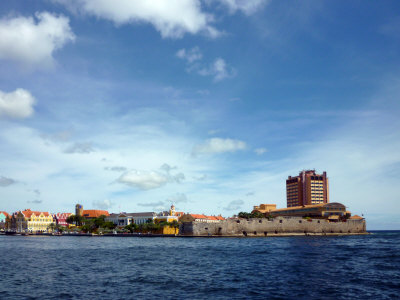
The Queen Emma Pontoon Bridge and Colonial Gabled Buildings. Willemstad, Curacao D. A. Levy, Photographer |
Bismarck Daily Tribune, May 20, 1890, Bismark, North Dakota, USA
A Curious Drawbridge.
"One of the most curious drawbridges in the world," said an officer of a West India fruit steamer, "is in the harbor called St. Ann's Bay, in the Island of Curacao. It is a pontoon bridge, and one of the pontoons is a steamer. The steamer was built in Camden, Missouri. It is a scow 40 feet long, 12 feet wide and 7 feet deep. There is a single shaft that runs clear through the boat, and has a 40 inch screw propeller on each end. The shaft is turned by two 9x12 steam engines. When the draw is to be opened, the captain of the steam pontoon casts off the lines, gives a toot on the whistle, and sets the propellers a whirling, and thereupon half the bridge swings round far enough to let the coming ship pass through. Then the wheel is reversed and the gap is closed.
~ Exchange
By 1910 around 25 steamers were entering the harbor each month on regular lines from seven different countries.
By 1920, oil was discovered off the Venezuelan coast. This signaled a new era for Curacao, and for its sister island Aruba. The island is the birthplace of the famous liqueur, Curacao, perhaps more well known outside of Curacao than the island is.
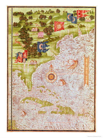 |
Map of Florida and the Antilles from Cosmographia Universelle. 1555 Guillaume Le Testu |
1899. World's Fleet. Boston Daily Globe
Lloyds Register of Shipping gives the entire fleet of the world as 28,180 steamers and sailing vessels, with a total tonnage of 27,673,628, of which 39 perent are British.
| Great Britain | 10,990 vessels, total tonnage of 10,792,714 |
| United States | 3,010 vessels, total tonnage of 2,405,887 |
| Norway | 2,528 vessels, tonnage of 1,604,230 |
| Germany | 1,676 vessels, with a tonnage of 2,453,334, in which are included her particularly large ships. |
| Sweden | 1,408 vessels with a tonnage of 643, 527 |
| Italy | 1,150 vessels |
| France | 1,182 vessels |
For Historical Comparison
Top 10 Maritime Nations Ranked by Value (2017)
| Country | # of Vessels | Gross Tonnage (m) |
Total Value (USDbn) |
|
|---|---|---|---|---|
| 1 | Greece | 4,453 | 206.47 | $88.0 |
| 2 | Japan | 4,317 | 150.26 | $79.8 |
| 3 | China | 4,938 | 159.71 | $71.7 |
| 4 | USA | 2,399 | 55.92 | $46.5 |
| 5 | Singapore | 2,662 | 64.03 | $41.7 |
| 6 | Norway | 1,668 | 39.68 | $41.1 |
| 7 | Germany | 2,923 | 81.17 | $30.3 |
| 8 | UK | 883 | 28.78 | $24.3 |
| 9 | Denmark | 1,040 | 36.17 | $23.4 |
| 10 | South Korea | 1,484 | 49.88 | $20.1 |
| Total | 26,767 | 87.21 | $466.9 | |

Site Search

Note: Illustrations on this site are here to bring the stories to life; if you wish to order a copy, reproductions are often available by clicking the image.
Creolization and Contraband: CuraCao in the Early Modern Atlantic World
(Early American Places)
Linda M. Rupert

A Brief History of the Caribbean: From the Arawak and Carib to the Present
Jews of the Dutch Caribbean: Exploring Ethnic Identity on Curacao
(Routledge Harwood Anthropology)
 History of the Caribbean
Caribbean Travel from Fodor, Frommer, Rough Guides, Kindle Books . . .
Birds of Aruba, Curacao, and Bonaire
Bart de Boer, Eric Newton, Robin Restall
(Princeton Field Guides)

Curacao: Religions, Rituals and Traditions
Sinaya R. Wolfert