Egypt
° Suez Canal (Port Said) ° Gods and Demons ° The Cats of Egypt ° The Horses of Egypt ° The Source of the Nile ° The Path of the Nile:
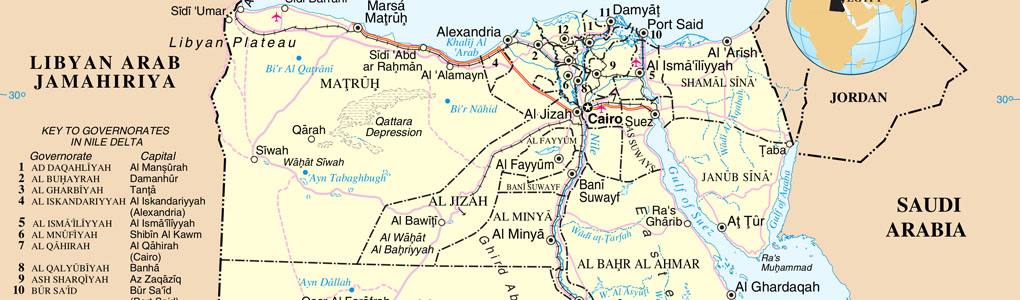
Egypt: The Suez Canal
French diplomat, Ferdinand de Lesseps, while serving in Egypt during the 1830's, became interested in building a sea-level canal across the isthmus. In 1854 he obtained an exclusive concession for the project from the pasha (governor) of Egypt. The concession specified that the waterway be open to ships of all nations and that it be turned over to the Egyptian government 99 years after completion.
Lesseps organized the Suez Canal Company and raised money by selling stock. More than half the shares were purchased by private investors in France, the rest by the pasha.
In 1854, Ferdinand de Lesseps, former French consul to Cairo, secured an agreement with the Ottoman governor of Egypt to build a canal 100 miles across the Isthmus of Suez.
In 1856, the Suez Canal Company formed and granted the right to operate the canal for 99 years after completion of the work.
The digging of the Isthmus of the Suez Canal commenced on the 26th of April, 1859; the first sod was turned by M. Ferdinand de Lesseps in the presence of the contractor of the works.
September 16, 1865, Mariposa Gazette, Mariposa, California, U.S.A. (From the Boston Daily Advertiser)
The Suez Canal.
Six hundred and thirty years before the Christian Era, Nicho, civil engineer of those day's, projected a ship canal across the Isthmus of Suez. The design was carried out by the Persian monarch Daris, the son of Hvstaspes. The canal continued in use, and was repaired as late as the reign of the Emperor Adrian, and finally fell into disuse and decay in the time of the Califs, who had a royal disregard of any commerce but that of the desert.
Bonaparte, always touched with the admiration at the achievements of antiquity, eagerly obeyed the orders of the Directory, that the canal should be surveyed and more opened to navigation. In company with M. Lepeec and a corps of savants and engineers, he began the exploration on the 30th of December, 1798, and traced the old route through to Calbeis in three days. At the time the French engineer reported that the Red Sea was thirty feet higher than the Mediterranean, a theory denied by La Place, and since conclusively disproved. The scheme which Bonaparte would have carried out had he remained in the country, was a connection between Cairo and Suez, and from the Nile to the Arabian Gulf. M. Lepere hints at a direct canal between Suez and Pelosium. Plans were made in the days of Mehemet Ali, but that shrewd old warrior refused to make any thoroughfare for men of war into Egypt.
The first modern company formed with the design of cutting the canal was in February 1841 by M. Livant, civil engineer to the Viceroy of Egypt. Another was organized by M. Enfantin, Stevenson and others, in 1816. Nothing came of either of these projected enterprises. But on the 30th of November, 1861, Said Pacha, the Viceroy of Egypt, granted certain rights to M Ferdinand de Lesseps, subject to the decision of the Sultan, and the attention of European nations was called more seriously to the subject.
The Suez Canal, 1864. Albert Reiger

An International Commission was appointed, consisting of four gentlemen from England, a like number from France, and one each from Austria, Piedmont, Holland, Prussia and Spain. The members were all officers of public works or naval gentlemen, well qualified to pronounce an opinion on the subject. At Suez, a port at the head of that gulf, they found a secure roadstead, with ample space for five hundred ships, and a depth of water of from sixteen to forty feet. The bottom was soft mud, but afforded good anchorage. It was estimated that a sea wall, extending into the water 5,200 feet on the north, and 3,900 feet on the south side, would give all required protection to the harbor.
The quarries of Attaka, near at hand, would furnish the material. From Suez to Pelusium the Mediterranean, by the most direct route, the distance is ninety miles. Having spent five days at Suez, the commission proceeded partly in the track of the old canal to the Mediterranean. In many places they found the canal to be one hundred and twenty feet wide, and from twenty to twenty five feet deep, which, if it can he regarded as any indication of its original size, must have been room enough and to spare for the galleys of the time. The land along the way was low and marshy, rising seldom above four or five feet from the level of the ocean, and having several muddy depressions, dignified with the names of lakes. Water obtained by boring was in tensely bitter, but there was no evidences of inconvenience from drifting sands. The Bay of Pelusium is thirty-seven miles wide between the promontories of Damietta and Cassius, and extends inland thirty miles. It is bordered by a strip of sand beach, just outside of which the Nile deposits its great belt of mud. The sea walls and piers required on this side, to guard against the uncertain current and the annual encroachments of the Nile, are of formidable extent. The materials are at hand in the inexhaustible quarries of Cyprus, Rhodes, Scarpanto, and the Syrian coast.

The report of this commission proving favorable, M. de Lesseps (image left) and his companions began operations. Fifteen millions francs were subscribed at once to the enterprise in Alexandria. For the prosecution of the enterprise it was necessary to have fresh water for the laborers. A canal was cut from the Nile to Ismaila, at the head of Lake Terasah, at the center of the isthmus, and from thence water is carried in iron pipes toward Port Said. A service canal is also projected northward to carry men and materials. The land along the borders of this fresh water canal, which is made fertile by the Nile water, was granted to the contractor, and also a large tract at each seaport for tho construction of works.
Out of these grants, which the Sultan refused to confirm, afterward arose some diplomatic difficulties, but the matter was finally referred to the arbitration of Napoleon III, who who settled the affair in a manner more satisfactory to himself than to the English, who are exceedingly jealous of French influence in this quarter.
The whole project of M. de Lesseps is a most magnificent one. It contemplates a ship canal ninety miles in length, three hundred and twenty feet wide, and twenty feet deep at the low water level of the Mediterranean. Port Said, near the Damietta mouth of the Nile, and Suez on the other side of the isthmus, are to become important maritime cities, and the fertilizing waters of the Nile will cause the desert sands along which it is carried to blossom like the rose.
1869: Railroad station at Ismaila

Midway been the seas, at the head of lake Timsah, Ismaila, a town of 3,000 inhabitants, has arisen to supply the wants of the laborers. The waters of the Mediterranean now flow to supply this place, at an average depth of about three feet. From here the fresh water canal is navigable for boats to Suez. It is said that the company have contracted with various French firms for the completion of the whole of the works from the Mediterranean to the Red Sea by the 1st of July, 1868, at which date the company expect that the canal will be open to navigation at a cost to the shareholders not exceeding the subscribed capital of 8,000,000 sterling.
Opening of the Suez Canal
EGYPT: Inset Cairo and the Suez Canal. Harmsworth, 1920.

On November 17, 1869, the Suez Canal opened in Egypt (101 miles across the Isthmus of Suez), thereby linking the Mediterranean and the Red seas and separating the Sinai from the rest of Egypt. Upon completion, the canal was 25 feet deep, 72 feet wide at the bottom, 200 to 300 feet wide at the surface and fewer than 500 ships navigated it in its first full year of operation (today more than 50 ships per day navigate the canal daily, carrying more than 300 million tons of goods each year).
Once the canal became a reality, British fear that the French might use it against British interests was replaced by recognition of its strategic as well as its commercial value to Britain. Within a couple of years, British troops were passing through at the rate of 35,000 a year. Concern for possible interference led to Disraeli's purchase of the Khedive's block of shares in the French Suez Company and to ever deepen British involvement in Egyptian affairs.
 |
Suez Canal - S.S. Nygeer |
This ship canal became a major navigational route for world trade. It crosses the Isthmus of Suez and links the Mediterranean Sea with the Gulf of Suez, an arm of the Red Sea, thus eliminating the long voyage around Africa for ships traveling between East and West. The canal has no locks, there being virtually no difference in the levels of the Mediterranean and Red seas.
The Canal proved to be of great benefit for the passage of troops in the First World War, and a Turkish attempt to interdict this traffic was repulsed. In the Second World War a determined attempt by the Axis to seize the canal was fought off at enormous cost.
Port Said
 |
|
Inauguration of the Suez Canal
|
Situated largely on man-made land, and geographically isolated, the city was founded in 1859 on a low sandy strip separating the Mediterranean from Lake Manzala (Buhayrat al-Manzilah). Mud and sand dredged from the harbour and huge artificial stones capable of resisting saltwater action were added to the strip; its breakwaters were completed in 1868, a year before the canal was completed. The city was named after the khedive Mujammad Sa?id (reigned 1854 63), who selected the site of the town.
Consisting initially of a grid-pattern European quarter and a native Egyptian sector, the town early established its cosmopolitan character. The outer harbour, 570 acres (231 hectares) in area, was carefully designed so that its two protecting moles, or breakwaters, prevent coastal currents from silting up the canal. The main channel is 2.5 miles (4 km) long, flanked by open basins. To house workmen of the several huge dry docks built between 1903 and 1909, a new quarter, now named Bur Fu?ad (Port Fuad), was built opposite the city proper on the eastern shore between the canal and the eastern extension of Lake Manzala.
Because of the building of the Canal, Port Said had years of prosperity from fishing and from industries such as chemicals, processed food, and cigarettes.
The Canal was opened to traffic at a moment when steam propulsion had just become competitive with sail for the shipping of bulk cargo.

Adoption of the compound engine, coupled with higher steam pressures derived from better boilers, had tipped the scales.
In 1853, out of a total of 10,000 ships on Lloyds' Register, only 187 were steamers.
After 1869 the sailing ship was rapidly displaced on the Passage East, and by the end of the century between four and five thousand ships a year were passing through the Canal. All were steamships, and seven out of ten were British. Port Said is also an important harbour both for exports of Egyptian products like cotton and rice, but also a fuelling station for ships that pass through the Suez Canal.

Site Search

Alexandria: A History and Guide
E. M. Forster

Peoples of the Sea
Immanuel Velikovsky (Russian-Jewish Independent Scholar. 1895-1979.)
This was the third published volume of Velikovsky's controversial reconstructions of ancient Egyptian history. This volume contains an appendix that every scholar or reader interested in the subject is advised to read. It is the story of how the conventional history of ancient Egypt was dated.
The Ptolemies, the Sea and the Nile: Studies in Waterborne Power
Editors: Professor Kostas Buraselis (University of Athens), Mary Stefanou (University of Athens), Dr. Dorothy J. Thompson (Cambridge)
Within the developing Aegean empire of the Ptolemies, the role of the navy and its admirals is examined. Egypt's close relationship to Rhodes is subjected to scrutiny, as is the constant threat of piracy. Along with the trade in grain came the exchange of other products. Ptolemaic kings used their wealth for luxury ships. Alexandria, the new capital of Egypt, attracted poets, scholars and philosophers; geographical exploration by sea was a feature of the period.

Egyptian Language: Easy Lessons in Egyptian Hieroglyphics
E.A. Wallis Budge
Ancient Egypt: Facts, Stories, Activities
(Journey into Civilization)
Robert Nicholson