Cambodia
The Khmers and Angkor Wat
Natural resources of Cambodia include timber and gemstones, which were desired by early traders who developed trading settlements along the coastline.
Early voyagers and geographers knew the people of Cambodia as Khmer.
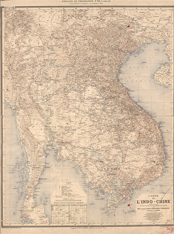 Map Of Vietnam Laos Cambodia In French 1895
These ports of call were used by boats following the trade routes from the Bay of Bengal to the southern provinces of China.
During the 6th century, Cambodia's population gradually concentrated along the Mekong and Tonl Sap Rivers, perhaps related to the development of rice agriculture.
Cambodia's history is exotic; between 900 and 1200 AD, the Khmer Kingdom of Angkor produced some of the world's most magnificent architectural masterpieces on the northern shore of the Tonle Sap, near the present town of Siem Reap. Approximately 72 major temples and other buildings are in the area. Angkor Wat, the most dramatic of the structures, was built between 1112 and 1150. Walls nearly on-half mile stretch along each side.
The Portuguese found their way to Cambodia not long after the conquest of Mallacca. Spanish authorities at Manila (1594-1598) engaged in "filibustering" expeditions to Cambodia with little result.
In the 1620s the Cambodian king turned to the Vietnamese for help against the Thais, permitting Vietnamese settlement along his kingdom’s southeast coast. There the Vietnamese port and stronghold of Saigon would develop. Vietnamese and Chinese adventurers and traders began to dominate other Cambodian ports. European accounts of Cambodia in the late 16th century and first half of the 17th century suggest a cosmopolitan trading life involving Chinese, Japanese, Malay, Arab and other traders. English trade with Cambodia began as early as 1616, the Portuguese followed with some factories, and then the Dutch established a Dutch factory. In 1641 Gerard van Wusthoff of the Dutch factory conducted an expedition up the Great River to Vienchang, the capital of one of the Laos states, about 1000 miles from the sea a feat never repeated till the French missions of 1866-68.
The English established a factory at Pulo Condore, a group of islands off the coast of the Cambodian delta in 1702, but this came to an end in the massacre of its members by the Macassar Sepoys of the garrison. But from the mid-17th century Cambodia became increasingly isolated from the sea, caught in the pincer movement of Thai and Vietnamese expansionism.
In 1810-12 the districts adjoining the Great Lake were seized, followed by the whole Delta and Cambodia was reduced to its present limits. In 1846 a king was enthroned under the joint investiture of Siam and Cochin-China. The French invasion of the Anamite provinces in the Delta took place in 1859.
Cambodia's rich and powerful past under the Hindu state of Funan and the Kingdom of Angkor was on the verge of dissolution by the mid-19th century. After repeated requests for French assistance, a protectorate was established in 1863; in 1864 the king, Morodam, was crowned in the presence of a French and of a Siamese representative; and a treaty was concluded, placing the kingdom under joint protection of those two powers. By 1884, Cambodia was a virtual colony; soon after it was made part of the Indochina Union with Annam, Tonkin, Cochin-China, and Laos. France continued to control the country even after the start of World War II.
The great river Mekong, known also as the Cambodia River, a name bestowed when its delta yet belonged to Cambodia, flows through the existing territory for about 250 miles, from North East to South West.
The "Great Lake," is a shallow depression in an alluvial plain, retaining a part of the animal overflow of the rivers throughout the year, and subject to great variations in depth and extent. In the rains it is said to have a length of about 100 miles. with a breath of one third as much. Its average depth in the dry season is only 4 feet. The Udong River, running between the lake and the Mekong, fills a channel of great breadth. Its waters change their direction half-yearly, from June to December filling the lake from the Mekong, and from December to June draining the lake into the Mekong. The fishery is important to the people; it is carried on in the dry season, during which time extensive pile-villages are erected in the lake, where the drying and salting of the fish is carried on for use and trade.
Cambodia has two major ports, Phnom Penh and Sihanoukville, also known as Kampong Som, and five minor ones.
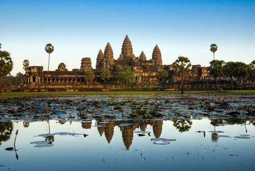 Angkor Wat
 Phnom Penh, located at the junction of the Basak, the Mekong, and the Tonle Sab rivers. It remains an important port for international commerce as well as for domestic communications. Sihanoukville is Cambodia's only deep water seaport.
The nation's extensive inland waterways were important historically in domestic trade. The Mekong and the Tonle Sap Rivers, their numerous tributaries, and the Tonle Sap provided avenues of considerable length, including 3,700 kilometers navigable all year by craft drawing 0.6 meters and another 282 kilometers navigable to craft drawing 1.8 meters. In some areas, especially west of the Mekong River and north of the Tonle Sab River, the villages were completely dependent on waterways for communications. Launches, junks, or barges transported passengers, rice and other goods produce and goods.
April 3, 1873, North China Herald, Shanghai, China
Fraser's Magazine on "The Press" In China.
Editorial Selections:" . . . Besides its own proper territory, the French Government exercises a protectorate over the Kingdom of Cambodia, whose territory, imbedded between Annam and Siam could hardly escape feudal subjection to one or other of these more powerful neighbors. When the French conquered Saigon, Cambodia was greatly under the influence of Siam; but M. de Carne has lately told us how the political skill and firmness of the newcomers eventually defeated the Court of Bangkok, an
d how the treaty of 186S eventually placed King Norodom under the protectorate of France."
Angkor Wat
Nothing prepared the Western World for the findings of a French missionary, who was also a naturalist, in the 1850s. He accidentally came across Angkor, one of the largest religious structures in the world. Built between roughly A.D. 1113 and 1150, and encompassing an area of about 500 acres (200 hectares)
Its name means “temple city.” The builder of Angkor Wat was a king named Suryavarman II. A usurper, he came to power in his teenage years by killing his great uncle, Dharanindravarman I, while he was riding an elephant.
Originally built as a Hindu temple dedicated to the god Vishnu, it was converted into a Buddhist temple in the 14th century, and statues of Buddha were added to its already rich artwork. Its 213-foot-tall (65 meters) central tower is surrounded by four smaller towers and a series of enclosure walls, a layout that recreates the image of Mount Meru, a legendary place in Hindu mythology that is said to lie beyond the Himalayas and be the home of the gods.
By the 1200s, the temple was abandoned and taken over by the jungle. In 1860, the French led an expedition into the heart of Cambodia attempting, inspired by the European hunger for exploration and discovery. Since the mid-1800s Europe and the West have been spellbound by the ancient city of Angkor Wat. The French pioneered an Angkor Wat restoration project in 1908 that continues to this day.
Angkor Wat portrays the Hindu cosmology with the central towers representing Mount Meru, home of the gods; the outer walls represent the mountains enclosing the world, and the moat represents oceans.
During the 15th century, nearly all of Angkor was abandoned during attacks from the Siamese, with the exception of Angkor Wat, which remained a shrine for Buddhist pilgrims.
Eventually the jungle overtook Angkor Wat and the structures remained virtually shrouded from European eyes until Henri Mouhot, a French naturalist, "stumbled" across Angkor Wat during a tour of Siam, Cambodia, Laos and Annam.
August 27, 1864, Sacramento Daily Union, Sacramento, California, U.S.A. Life Among the Savage Stiens.We are surrounded by forests which are infested with elephants, buffaloes, rhinoceros, tigers and wild boars, and the ground all about the pools is covered with their footprints. We live almost as in a besieged place, every moment dreading some attack of the enemy, and keeping our guns constantly loaded. Sometimes they came close to our quarters, and we cannot go even a few steps into the woods without hearing them. As a general rule, however, they fly from the approach of man, and in order to get a shot it is necessary to lie in wait either amongst the branches of a tree or hidden amid, the brushwood near the spots where they come to drink. Scorpions, centipedes, and above all, serpents, were the enemies we most dreaded, and against which precautions ere chiefly requisite; but the myriads of mosquitoes and the leeches, though less dangerous, were the most troublesome and most inveterate plagues. During the rainy season you cannot be too much on your guard; going to bed or getting up, you are ever in peril of putting hand or foot on some venomous snake. I have killed more than one in my house with a gun or a hatchet. As I write I am obliged to be continually on the watch, fearing to see one reappear on which I trod this evening, but which made his exit without hurting me. From time to time, also, I stop to listen to the roaring of a tiger, who is wandering round our dwelling and looking longingly at the pigs through their fence of planks and bamboos. Again, I hear a rhinoceros breaking down the bamboos, which oppose his progress toward the brambles encircling our garden, on which he intends to banquet. Mouhot's Travels in Indo- China. |
May 1, 1893, London and China Telegraph, London, England
Journeys in French Indo-China
A large and distinguished company, including the Prince of Wales and the Duke of Fife, was present on the 24th ult. at a meeting of the Royal Geographical Society, held under the presidency of Sir M. E. Grant Duff to hear a paper by the Hon. George N. Curzon, M.P. on his "Journeys in French Indochina." The lecture was illustrated throughout by a number of excellent photographs thrown on a screen in the usual way, some of them representing the famous ruins of Angkor Wat. In his remarks Mr. Curzon said:
The geographical interest of this country consists in the immense rivers by which it is intersected, and to whose alluvial bounty it is for the most part due, and to the mystery which still overhangs its interior recesses, where on the confines of China, Burma, Siam, and Annam, wild and little known tribes inhabit the pathless mountains, and unexplored rivers thunder down profound ravines. Its commercial interest lies in the competition which it has engendered between rival European nations for the easiest approaches to the remote but populous provinces of Western China, on whose borders it lies.
Its political interest lies in the fact that within the last thirty years the ownership of this vast tract, obeying the universal law by which the hitherto hidden corners of the world are gradually yielding up their secrets to civilization has changed and is even now changing hands; the conquest of the French having placed them in possession of the whole of its eastern face from Cambodia to long-King, and the acquisition of Upper Burma by the British having brought the latter into similar contact both with China herself and with the frontiers of the one surviving independent Asiatic kingdom, that now separates England from France in the Far East, viz., Siam. I will first deal with the main geographical characteristics presented by this dominion, the different sections of which possess a physical unity that facilitates the task of description.
In no part of the world has water exercised a more potent agency in determining the destinies or in providing the livelihood of man. The bulk of the French possessions owe their existence to the deposits of great rivers. The entire populated and wealthy part of Tong-King consists of the delta of the Red River and its confluences, which is 80 miles broad at its base. The whole of Cochin China and much of Cambodia consists of the delta of the Mekong. In each of these regions, under conditions differing very slightly, the process of territorial formation, or encroachment upon the sea, can be watched in active development. In Annam the growth of the land at the expense of the sea is accelerated by the action of the tides and winds, principally the north-east monsoon, which pile up long sand-dunes upon the coast, behind which the rivers, unable to pour their entire volume into the sea, spread themselves out in broad and sluggish lagoons, chafing idly to and fro, and daily diminishing in depth, till they too submit to the inevitable process and are choked.
One other phenomenon common to these regions is the existence of a peculiar rock formation, composed of a calcareous stone or marble, superimposed above the Devonian schists, and presenting the most picturesque and fantastic contours both in the sea, at no great distance from the mainland, and also at several points along the river valleys which have in earlier days been similarly situated It consists of detached blocks or humps of rock, rising to a height of from 50 to 500 feet, with scarped sides and faces, but with summits and ledges covered with a superb and gracious vegetation. The action of the sea has carved the sides and hollowed the interior of these rocks into vast caverns and grottoes, and has fretted their outline into strange and abnormal shapes.
TRAVELS IN CAMBODIA.
Travels in Cambodia will, in the case of most voyagers, take the form of a visit to the capital Pnompenh, and to the famous Khmer ruins of Angkor. The ruins are situated at a distance of about twelve miles inland from the north-west extremity of the Talay Sap or Inland Sea, whose waters and coasts are divided between Cambodia and Siam. The entire lake, which is a comparatively late creation, appertained to Cambodia, until the wars at the end of the last century transferred the provinces of Angkor, or Siem Reap, and of Battambang on its north and south shores to Siam. The latter has remained in possession of them ever since, and has been confirmed in her ownership by a treaty concluded in 1867 with the French, after the latter had assumed the protectorate of Cambodia. Though Cambodian in historic association and surroundings, the ruins of Angkor are therefore now in Siamese territory a source of great annoyance to the French, and of some mortification to the Cambodians.
The north shore of the great lake of Talay Sap (called by the French, for what reason I do not know, Tonle' Sap), is one of the most peculiar in the world. Its only coast-line is the stems of trees, the greater part of whose height is immersed below the surface of the water, and is only entirely laid bare during the dry season. Through the upper branches of these the river of Siem Reap lastly struggles to the lake. It was the beginning of January when I made the ascent, and the water was already sinking rapidly. At a point whence it was impossible to continue further by the river, horses and oxen had been sent to meet me by the Siamese Governor of Siem Reap, who had been apprised of my arrival from Bangkok. A ride of one hour and a-half brought me to the town of that name, and capital of the province, administered by a governor subordinate to the Royal Commissioner at Battambang. The town consists of a few thousand people. A sala, the Siamese expression for a rest-house, and substitute for the Annamite tram, is here placed at the disposal of strangers, but will not as a rule be occupied by anyone anxious to push on to Angkor. A further ride of about three and a-half miles along an excellent path through beautiful jungle scenery, will bring him to the outer terrace of the great temple of Angkor Wat.
After a very careful study of all the remains, which cover an area of some 20 miles square, I will say;
- as regards their purpose, that they were neither dedicated to snake worship, as imagined by Fergusson in his "History of Architecture;" nor to Buddhism as supposed by Gamier, de Legrce, and Mouhot; nor to a mixture of the two, as inferred by Vivien St. Martin; but to Brahmanism, pure and simple, upon which, at a later date, were grafted Buddhistic additions, the statues of Buddha in many cases, after the introduction and triumph of that faith, replacing the images of the Hindu deities in the niches and shrines;
- as regards their origin, that they were constructed by a race, known as the Khmers, who came, in all probability overland, from India, conquered the country, and acquired its throne, but whose traces, except in so far as they are merged in the modern Cambodians, have entirely disappeared;
- as regards their date a matter in which we have received invaluable assistance from the inscriptions that have been deciphered by French scholars that they were erected at different periods between 700 and 1100 A D.;
- as regards their material, that all the older buildings are constructed of two varieties of stone a hard, fine-grained sandstone, invariably employed for the sculptures, and a coarse porous red stone for the substructures ; but that the later buildings are made of well-burned and durable bricks;
- as regards their architectural features, merits and style, that they constitute on the whole the most remarkable body of ruins in the world, whether we regard the prodigious magnitude of the ground plan, the grandiose dimensions of the principal palaces and temples, or the artistic beauty and delicacy of the bas-reliefs and sculptures;
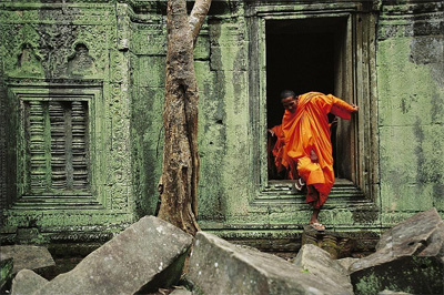
- as regards their present condition, that, with the exception of the great temple of Angkor Wat, which is in its essential features comparatively well preserved, the buildings are fast tumbling to pieces, being buried in a deep jungle through which a path has often to be cut with a billhook in order to reach them, and whose trees and creepers, insinuating themselves between the stones, are rapidly causing them to fall into irretrievable ruin.
The remains practically consist of seven main groups, situated at wide distances apart and separated by obscure jungle paths. They are:
- the ruins of the hill of Pnom Krorn and at Athvea, on the right bank of the Siem Reap river, near the lake.
- The great temple of Angkor Wat, 3-1/2 miles north-west of Siem Reap.
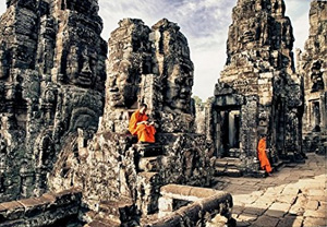
- The hill of Bakheng, 1/2 mile north-west of Angkor Wat, and the multitudinous ruins contained either inside or immediately outside the vast inclosure of Angkor Tom, the royal city, situated a little further in the same direction.
- The great lake and summer palace of Baria Mebom, about 5 miles to the west.
All these are on the right, or west bank of the river. Then on the other or east bank are
- the group containing the ruins of Prasat Kao, Taprom, Kedei, and the artificial lake of Sra Sang;
- to the south of these, the brick group of Bachoum, Mabon, and Prea-rup and;
- considerably to the south of these, and about 8 miles almost due east of Siem Reap, the brick group of Lolie, Pra-ko, and Bakong.
It is only by visiting all of these remains that the visitor can form a fair idea, not merely of the scope and range of the Khmer architecture, but of the different features that marked its growth, zenith, and decline.
November 25, 1893, San Francisco Call
San Francisco, California, U.S.A.
RUINS OF ANG-KOR.
Relics of an Ancient Asiatic Race That Were Great Builders.
Recent events have attracted attention to the great lake between Oombodia (Cambodia) and Siam, Touie Sap and the two Siamese provinces of Ang-Kor and Battambong, which adjoin it. A few months ago the Progres de Saigon issued an account, illustrated by native wood engravings, of this great lake of the two provinces and of the famous ruins of Ang-Kor.
The region is described as lying to the north of Cochin-China, between Siam, the ocean and the unknown Laos districts, and although now but thinly populated it was in former times the abode of a race which was great among the people of the East, and which for long centuries was governed by a famous line of sovereigns. The great lake is formed during the rainy season by one of the branches of the Mekong, and is then navigable by large steamers, which go to Siemreap, at the head of the lake, and near the ruins of Ang-Kor, the greatest remains of Khmer civilizations.
These ruins were discovered by the Portuguese and Spaniards in 1564, and they were first described in a volume published in Barcelona in the following century.
There are Chinese accounts of a much earlier period, and one of these, written in the thirteenth century by an ambassador sent to me Cambodian court, was made known to Europe by Abel Remusht. It Includes descriptions of the two famous temples of Ang-Kor Wat and Ang-Kor Thom, which correspond with the ruins of the present day.
Since then they have been investigated by French savants, and quite a splendid work on the subject has been published by M. Fournereau.
It is thirty hours' steam to Pnom-Pen, the capital of Cambodia, and thirty more to Siemreap. Ang-Kor Wat, or Ang-Kor the Great, the royal pagoda, is the best preserved of all the Khmer remains. Mouhot, who visited it in the year 1862, says it is more majestic than any other monument of antiquity that we possess. It occupies a large rectangular park, 1087 miles long and 827 broad. The illustrations show numerous towers, vast terraces, several subsidiary temples, innumerable figures of fantastic mythological animals, galleries, colonnades. avenues, lakes, bridges, etc. The surfaces of the large stones employed in the buildings are covered with pictures and engravings. These huge blocks are believed to have been conveyed to the great heights at which some of them are found by means of inclined planes.
Ang-Kor Thom, which is a few miles away, is still more ancient, and around it are the ruins of the old Khmer capital, Preathong, which have been invaded by the forest, giant banyans having their roots below the foundations and their branches among porticos and pillars covered with bas-reliefs. These latter, which are especially well preserved in the underground galleries, represent the national sports, sacred ceremonies and historical events of the Khmers. These are the two main Khmer monuments, but there are hundreds of others that are scattered over a large area of the country in the midst of what looks like a primeval forest.
Angkor: Before And After
(A Cultural History Of The Khmers)
David Snellgrove
The Khmers were first noticed by the Chinese when they began to occupy neighboring maritime politics in the first few centuries AD; their own recorded history commences with inscriptions from the 5th century onward. Having consolidated their control over the territory now known as Cambodia, they extended their power northward and westward, eventually occupying almost the whole area of present day Thailand. Although Cambodia has since contracted into a small country, it remains famous for its great monuments from the past. The result of some ten years of research, this authoritative description of the rise and eventual fall of the Khmer empire includes color illustrations, not only of the better known monuments but of many of the more obscure sites complement the text.

1899. World's Fleet. Boston Daily Globe
Lloyds Register of Shipping gives the entire fleet of the world as 28,180 steamers and sailing vessels, with a total tonnage of 27,673,628, of which 39 perent are British.
| Great Britain | 10,990 vessels, total tonnage of 10,792,714 |
| United States | 3,010 vessels, total tonnage of 2,405,887 |
| Norway | 2,528 vessels, tonnage of 1,604,230 |
| Germany | 1,676 vessels, with a tonnage of 2,453,334, in which are included her particularly large ships. |
| Sweden | 1,408 vessels with a tonnage of 643, 527 |
| Italy | 1,150 vessels |
| France | 1,182 vessels |
For Historical Comparison
Top 10 Maritime Nations Ranked by Value (2017)
| Country | # of Vessels | Gross Tonnage (m) |
Total Value (USDbn) |
|
|---|---|---|---|---|
| 1 | Greece | 4,453 | 206.47 | $88.0 |
| 2 | Japan | 4,317 | 150.26 | $79.8 |
| 3 | China | 4,938 | 159.71 | $71.7 |
| 4 | USA | 2,399 | 55.92 | $46.5 |
| 5 | Singapore | 2,662 | 64.03 | $41.7 |
| 6 | Norway | 1,668 | 39.68 | $41.1 |
| 7 | Germany | 2,923 | 81.17 | $30.3 |
| 8 | UK | 883 | 28.78 | $24.3 |
| 9 | Denmark | 1,040 | 36.17 | $23.4 |
| 10 | South Korea | 1,484 | 49.88 | $20.1 |
| Total | 26,767 | 87.21 | $466.9 | |

Site Search

A Record of Cambodia:
The Land and Its People
Zhou Daguan
Translated with an Introduction and Notes by Peter Harris
Zhou Daguan's 700 year old report of his diplomatic journey to the fabulously wealthy ancient Khmer capital of Angkor is rare. In fact, it is one of the only written records about this mysterious kingdom that has survived to the present day.
Temples of Cambodia:
The Heart of Angkor
Bruce Brukoff and Helen Ibbitson Jessup
The temples of Cambodia are among the most complex and imposing architectural creations in the world. Experience these extraordinary sites through remarkable photographs and a text by a leading Khmer cultural historian. From modest brick structures in the seventh and eighth centuries, the temples became increasingly ambitious, setting the stage for the apogee of the Khmer empire and with it, the supreme architectural creation of Cambodia, Angkor Wat. Barry Brukof's splendid photographs record temples that have been destroyed but also offer an insight into the Cambodian idiom, and with Helen Ibbitson Jessup's expert text, allow readers to penetrate to the heart of the temple's mystery.

The Khmers
(History and Treasures of an Ancient Civilization)
Stefano Vecchia
Travels in the Central Parts of Indo-China (Siam), Cambodia, and Laos.
1858, 1859, 1860
M. Henri Mouhot
French naturalist Mouhot "discovered" Angkor Wat by accident as he travelled the jungles of Cambodia during the 1850s. His book includes black-and-white drawings depicting nature, people, kings and temples.

Cambodian for Beginners:
Second Edition
Richard Gilbert
Sacred Places of a Lifetime:
500 of the World's Most Peaceful and Powerful Destinations
National Geographic
Iconoclasm from Antiquity to Modernity
Kristine Kolrud