Spain
° Barcelona ° Cadiz ° Canary Islands ° Cordoba ° Islas Baleares ° San Sebastian (Basque) ° Valencia
International Harbors
Spain's geographic location at the entrance to the Mediterranean is, in many ways, both a blessing and a curse. With it's 7,000 kilometers of coastline, Spain has historically been a maritime power and a conduit for goods travelling from North Africa and the Middle East to Europe.
Spain and Portugal. Longman. 1828.

Spain's seaports contributed to its rise to global power more than 500 years ago. Excavations have found Phoenician settlements strong enough to have survived the fall of Tyre (in 573 BC) and subjugation of eastern Phoenicia. Abdera (Adra), Baria (Villaricos), Carmona (Carmo), Gadir (Cadiz), Malaca (Malaga), and Sexi (Almuqecar) all prospered in an area where trade was controlled through Carthage. Commerce with Eivissa (Ibiza) on the Balearic Island extended Carthaginian influence even further north. Finally, Cartago Nova (Cartagena) was established late in the 3rd century BC as a base from which to mastermind the conquest of Spain.
Bayeau Y Subias, Francisco (1734-1795).

In 1588, the Spanish Armada was dispatched against England by Spain's Catholic King Philip II, leading to an early and important confrontation in the nearly 20-year Anglo-Spanish War of 1585-1604 (the "Twenty Years' War"). The Armada had been sent following a rift in Anglo-Spanish relations resulting from commercial competition, religious differences, and disputes over English aid to Protestant Dutch rebels. The Spanish fleet was repulsed by English defensive ships, however, and suffered major losses in a September Atlantic storm while rounding the coast of Scotland en route to Spain. The Spaniards were nonetheless able to regroup quickly, and defeated a retaliatory English invasion force dispatched to Spain and Portugal in 1589.
The Spanish navy was retooled in the 1590s and effectively solidified Spanish control over the waves, protecting treasure fleets from privateering while vanquishing English opponents on the high seas and on the coasts of Spanish America, and Spain continued as Europe's dominant power into the 1600s.
Spanish Migration to the Americas
Expulsion of Jews from Spain. 1492.

By 1600, phases of Spanish migration to the Americas had ended: the flow of explorers (1492-1519), the expulsion of Jews, and that of conquerors (1521-1548).
The discovery of silver in 1548 at Zacatecas, in north-central Mexico, led to a Spanish effort in colonization and settlement. In 1573, the "Ordinances of Discovery," promulgated by the Spanish crown, outlawed the brutal treatment of native Americans that had characterized the conquerors like Cortes, Vasquez de Coronado, and de Soto. After 1573, Catholic priests became the vanguard of Spanish expansion in the Americas in their establishment of missions to Christianize the native Americans.
Patterns of migration followed the Spanish missions. Once priests formed a mission community, soldiers followed, assigned to presidios (military camps) in order to protect the missions. On the heels of the soldiers came civilian settlements dedicated to providing food, clothing, and other goods for the presidios and missions. The 1573 Ordinances and the 1681 "Recompilation of the Laws of the Indies" gave strict regulations for the formation of new communities in the Americas.
In the seventeenth century, Mexico City, originally built by the Aztecs in an island in Lake Texcoco, was by far the most populous city in North America. Churches, chapels, convents, schools, homes, hospitals, public baths, and government buildings were built by the Spanish on the Indian site. In 1700, about 100,000 people lived in Mexico City, with about 100,000 more around the city. About half the population was Spanish, with about forty percent black or mixed and less than ten percent Indian.
Spanish America Slave Trade
A lucrative slave trade thus evolved to provide laborers for Spanish America. The asientos de Negros were contracts between the Spanish crown and slave-trading companies to the Central and South American colonies. An illegal slave trade also developed.
The Spanish brought slaves from English or Portuguese traders and shipped them into Mexico, the Caribbean, and other areas in Central and South America. Like the Portuguese, the Spanish found the native American population diminished at the very time that it seemed that plantations and mines were becoming increasingly profitable. African slaves, most of them packed into ships sailing to Mexico, provided labor to the Spanish settlers. In the seventeenth and eighteenth centuries, about 200,000 Africans were imported into Mexico, but in 1817 there were only 10,000 slaves there. Of these, only 6000 were identified as Negroes. High mortality served to diminish the number of slaves, while intermarriage with native Americans further diminished the number of those who would be identified as of African descent.
Hundreds of thousands of Africans were imported as slaves into other Spanish territories: Peru, Chile, Colombia, Venezuela, and the Spanish Caribbean (Santo Domingo, Puerto Rico, and Cuba).
Barcelona
From the 13th through the 18th Century, war and merchant ships were built in the Drasannes at Barcelona from the 13th until the 18th Century. The construction of the shipyards secured Barcelona's naval supremacy throughout the Mediterranean expansion; up to 30 galleys could be built simultaneously in the vaults. From 1792, the Drassanes were used as barracks.
April 2, 1873, Sacramento Daily Union, Sacramento, California, U.S.A.
The War In Spain
Lawlessness In Barcelona
Malaga Preserves Order but Resists the Government.
Madrid, March 31st. General Counteras, Captain General at Barcelona, has resigned and General Villende is his successor. It is expected that Catalonia will soon be declared in a state of siege. Acts of lawless violence are of daily occurrence in Barcelona. The burning of churches and massacre of priests are threatened. The authorities are doing all in their power to prevent such outrages. Ten thousand armed citizens maintain older in the city of Malaga, but refuse to admit the regular troops or Government custom officers, nor will they allow vessels conveying soldiers to other points to remain in port. They provide for their expenses by taxing the wealthy. The residents are in abeyance. Custom officials say smuggling is carried on to a large extent. The citizens are divided into two parties, the moderate and ultra-federalists. The moderates now have control, but the federals are gaining strength.
On June 11, 1890, the headquarters of a gang making immense quantities of bogus stuff purporting to be brandy, chartreuse and champagne was discovered in Barcelona, along with an extensive plant of printing presses. A dozen men were arrested in connection with the fraud, however, the head of the concern escaped to America. In 1891, the San Francisco Call reported that "six arrests were made at Barbera and three in Barcelona in connection with the recent revolutionary attempt to capture Barcelona barracks." It was stated that twenty conspirators "met in a cafe Saturday and concerted the details of the affair."
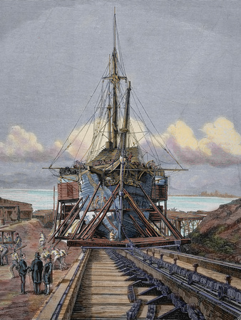 |
| The Dry Dock, Barcelona by Manchon Spanish and American Illustration , 1872 |
July 22, 1898, Sacramento Daily Union, Sacramento, California, U.S.A.
INTERVENTION OF FRANCE.
Movement at Barcelona to Ask France to Take Catalonia.

LONDON, July 21.
A Madrid special announces that telegrams received from Barcelona report a growing movement in favor of the intervention of France, and that steps are about to be taken to formally invite France to take Catalonia, of which Barcelona is the capital, and which has an area of over 12,000 miles, under her protection. Another dispatch from Madrid asserts that the inhabitants of the Canary Islands are panic stricken at the prospect of an American attack. The wealthy people have gone into the interior. Great misery prevails, trade is at a standstill, and there is considerable military activity everywhere, especially at Lanzarote and Graciosa Islands, which are expected to be the objectives of the American attacks, where strong garrisons are reported to have been installed and powerful batteries erected on mountains dominating the islands.
Cadiz
Cadiz, originally called Gadir (which means"an enclosure" in Phoenician), the earliest and most significant of the Phoenician ports on the Spanish coast, was a natural location for an outpost. Within easy reach of the Guadalquivir River, major source of alluvial deposits, and built on the protected shores of a narrow peninsula enclosing Gulf of Cadiz, this city is still today the capital of its province. Little remains of the ancient settlers, but excavations have led to the discovery of Phoenician sarcophagi. One of Spain's oldest and best-preserved Roman theaters was also discovered nearby.
Francisco De Miranda (1750-1816)
|

January 27, 1855, Atlas, London, United Kingdom
WINE DUTIES

The Cadiz papers give an account of Mr. Oliveira's visit to that city in connexion with this subject, and intimate the deep interest which all the great houses at Jeres and Port St. Mary's take in the question. The honourable gentleman, it seems, has made a complete survey of the various establishments and been most favorably received, added to which the leading commercial houses of Cadiz are beginning to view the principles of free-trade with some favour, even as regards a reduction of the Spanish tariffs. Mr. Oliveira is expected home early in February, when he will bring forward his motion on the wine duties.
Canary Islands
Peak of Teneriffe. Canary Islands.

Once known to the ancient Romans as the Fortunate Islands, the Canary Islands were named after the large dogs (Canes) found living on the islands. Located off the northwestern coast of Africa. The Canary Island's archipelago includes seven major islands, all remnants of very steep, extinct volcanoes: Fuerteventura, Gran Canary, Gomera, Hierro, La Palma, Lanzarote, and Tenerif.
July 22, 1898, San Francisco Call , San Francisco, California
PEOPLE ON CANARIES ARE PANIC-STRICKEN
LONDON, July 21. A Madrid special announces that the inhabitants of the Canary Islands are panic-stricken at the prospect of an American attack. The wealthy people have gone into the interior. Great misery prevails, trade is at a standstill, and there is considerable military activity ever-where, especially on Lanzarote and Graciosa islands, which are expected to be the objectives of the American attacks.
Jean de Bethencourt
Louis Garneray, 1848. |

Cordoba
Under the Moorish rule of Al-Hakam (796-822 A.D.) the great mosque of Cordoba was extended; he was also responsible for instituting the first university in Andalusia. Because of the Nizamiyyah University and the Bayt al-Hikmah of Baghdad and the Academy of Cordoba and the Qarawiyan of Fes, Cordoba thus became a great center of learning in Europe at a time when the rest of the continent was plunged in ignorance. During the Ninth and Tenth centuries, there were over 200,000 houses in the city along with six hundred mosques, nine hundred public baths, fifty hospitals and several large markets which catered for all branches of trade and commerce, including 15,000 weavers.
Peasants of Cordoba, Andalusia. c. 1885.

Cordoba was stormed and sacked by the French in 1808 for its part in fomenting the rebellion against Napoleonic French rule. It was one of the first cities occupied by Francoist forces in the Spanish Civil War (1936- 39).
Cordoba remained a typically Moorish city with narrow, winding streets, especially in the older quarter of the centre and, farther west, the Juder a (Jewish quarter). A Moorish bridge with 16 arches on Roman bases connects Cordoba with its suburbs across the river. The bridge is guarded at its southern end by the Calahorra fortress. West of the bridge, near the river, lies the Alc zar, or palace, which was the residence of the caliphs.
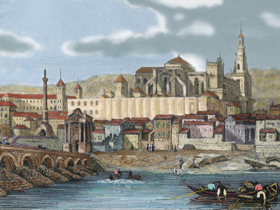 |
View of the City with the Mosque, Cordoba Andalusia, Spain |
Valencia
With the victory of the Bourbon Philip V in the early 1700s, Valencia was stripped of the special privileges and autonomy (Fueros) which the city had enjoyed since the reign of King Jaime. The French Bourbons ruled Spain until the War of Independence (1808-1813) when Napoleon sent troops into Spain and established his brother, Joseph Bonaparte as king. This triggered violent uprisings in Valencia as well as other Spanish cities and the French finally withdrew in 1813.
Spain and Portugal. 1825.
Arrowsmith, Mapmaker.

The early 19th century gave birth to what is referred to as the Renaixenca (Renaissance). This was the time when the Valenciano language (a form of Catalan) was rediscovered as part of the national heritage. In the late 19th century Valencia s city walls were demolished in order for the city to expand, although the Torres de Quart and Torres de Serranos were left. During the late 1800s, Valencia, along with much of Spain, was ravaged by cholera.
The Great Sea: A Human History of the Mediterranean
David Abulafia
Situated at the intersection of Europe, Asia, and Africa, the Mediterranean Sea has been for millenia the place where religions, economies, and political systems met, clashed, influenced and absorbed one another. David Abulafia offers a fresh perspective by focusing on the sea itself: its practical importance for transport and sustenance; its dynamic role in the rise and fall of empires; and the remarkable cast of characters--sailors, merchants, migrants, pirates, pilgrims--who have crossed and recrossed it.
Ranging from prehistory to the 21st century, The Great Sea is a history of human interaction across a region that has brought together many of the great civilizations of antiquity as well as the rival empires of medieval and modern times. Interweaving major political and naval developments with the ebb and flow of trade, Abulafia explores how commercial competition in the Mediterranean created both rivalries and partnerships.

Europe and the People Without History
Eric R. Wolf
University of California Press
"In this big and important book, Eric Wolf begins and ends with the assertion that anthropology must pay more attention to history. . . . It is with pleasure, then, that one reads a critical analysis that rejects pseudo- historical oppositions and explores with such care the historical processes by which primitive and peasant pasts have become a fundamentally altered primitive, peasant, and proletarian present."

~ William Roseberry, Dialectical Anthropology
The Seven Celtic Nations
The seven original
Celtic Nations:

- Eire (Ireland): Ireland is the third-largest island in Europe and the twentieth-largest island in the world. A Norman invasion in the Middle Ages gave way to a Gaelic Resurgence in the 13th century.
- Galicia (Spain): Galacia is in northwest Spain, and descends from one of the first tribes of Celtic heritage in Europe. The name Galicia comes from the Latin name Gallaecia, associated with the name of the ancient Celtic tribe that resided above the Douro river.
- Kernow (Cornwall): Cornwall forms the tip of the south-western peninsula of Great Britain. It was occupied in the Iron Age by Celts. Cornwall was a division of the Dumnonii tribe—whose tribal centre was in the modern county of Devon.
- Mannin (Isle of Man): The Isle of Man is located in the Irish Sea between the islands of Great Britain and Ireland, within the British Isles. It began to be influenced by Gaelic culture in the AD 5th century and the Manx language, a branch of the Gaelic languages.
- Breizh (Brittany): Brittany occupies a large peninsula in the north west of France. Its land area is 34,023 km² (13,136 sq mi). After the Neolithic period, Brittany became home to several different Celtic tribes.
- Alba (Scotland): Alba is the Scottish-Gaelic name for Scotland. It occupies the northern third of Great Britain and it includes over 790 islands. Groups of settlers began building the first known permanent houses on Scottish soil around 9,500 years ago, and the first villages around 6,000 years ago.
- Cymru (Wales): During the Iron Age and early medieval period, Wales was inhabited by the Celtic Britons. A distinct Welsh national identity emerged in the centuries after the Roman withdrawal from Britain in the 5th century, and Wales is regarded as one of the modern Celtic nations today.

The history of the Celtic cross goes back to a time before the Christian conversion of Scotland, Ireland and Wales. It’s believed by some that the four arms of the cross represents the four elements, earth, air, fire and water. They also represent the four directions of the compass, North, South, East and West. And finally the four parts of man, mind, soul, heart and body. The horizontal line of the cross symbolizes earth and the vertical portion symbolizes heaven.
Sources: The Celtic Crier, Gaelic Forge
1899. World's Fleet. Boston Daily Globe
Lloyds Register of Shipping gives the entire fleet of the world as 28,180 steamers and sailing vessels, with a total tonnage of 27,673,628, of which 39 perent are British.
| Great Britain | 10,990 vessels, total tonnage of 10,792,714 |
| United States | 3,010 vessels, total tonnage of 2,405,887 |
| Norway | 2,528 vessels, tonnage of 1,604,230 |
| Germany | 1,676 vessels, with a tonnage of 2,453,334, in which are included her particularly large ships. |
| Sweden | 1,408 vessels with a tonnage of 643, 527 |
| Italy | 1,150 vessels |
| France | 1,182 vessels |
For Historical Comparison
Top 10 Maritime Nations Ranked by Value (2017)
| Country | # of Vessels | Gross Tonnage (m) |
Total Value (USDbn) |
|
|---|---|---|---|---|
| 1 | Greece | 4,453 | 206.47 | $88.0 |
| 2 | Japan | 4,317 | 150.26 | $79.8 |
| 3 | China | 4,938 | 159.71 | $71.7 |
| 4 | USA | 2,399 | 55.92 | $46.5 |
| 5 | Singapore | 2,662 | 64.03 | $41.7 |
| 6 | Norway | 1,668 | 39.68 | $41.1 |
| 7 | Germany | 2,923 | 81.17 | $30.3 |
| 8 | UK | 883 | 28.78 | $24.3 |
| 9 | Denmark | 1,040 | 36.17 | $23.4 |
| 10 | South Korea | 1,484 | 49.88 | $20.1 |
| Total | 26,767 | 87.21 | $466.9 | |

Site Search


Port Cities of Atlantic Iberia,
c. 1500-1900
Patrick O'Flanagan, Professor and Head of the Department of Geography, University of Cork, Ireland.

Empires of the Sea:
The Siege of Malta, the Battle of Lepanto, and the Contest for the Center of the World
Roger Crowley
In 1521, Suleiman the Magnificent, Muslim ruler of the Ottoman Empire, dispatched an invasion fleet to the Christian island of Rhodes. This would prove to be the opening shot in an epic clash between rival empires and faiths for control of the Mediterranean and the center of the world. In Empires of the Sea, acclaimed historian Roger Crowley has written a thrilling account of this brutal decades-long battle between Christendom and Islam for the soul of Europe, a fast-paced tale of spiraling intensity that ranges from Istanbul to the Gates of Gibraltar. Crowley conjures up a wild cast of pirates, crusaders, and religious warriors struggling for supremacy and survival in a tale of slavery and galley warfare, desperate bravery and utter brutality.

The Pirates of the Mediterranean
W. H. G. Kingston

Trafalgar and the Spanish Navy: The Spanish Experience of Sea Power
John D. Harbron
A dramatic appraisal of the Spanish Navy and its defeat by the British at Trafalgar in 1805 disproves many long-held beliefs about the competence of the Spanish fleet. The author examines the factors that shaped the development of the Spanish Navy in the eighteenth century and maintains that the well-built ships and skilled forces were nowhere near as ineffective as they are usually represented. The book includes specifics of Spanish warship design and construction and is illustrated with beautiful contemporary plans, engravings, and photographs of ship models, some in full color. 208 pages. 120 illustrations.

Mediterranean Pirates
A selection of books about the Pirates of Barbary.

The Siege of San Sebastian 1813
(Bretwalda Battles)
Oliver Hayes
Written by a military author, this book explains the way battles were fought two centuries ago and explains the course of the action in an accessible, authoritative style. This lavishly illustrated ebook is a must for anyone interested in the Peninsular War. It includes an account of the action itself, and studies of the commanders, the armies, the weapons and the tactics as well.