The Port of San Francisco during the 1800s
January 4, 1856, Daily Alta California, San Francisco
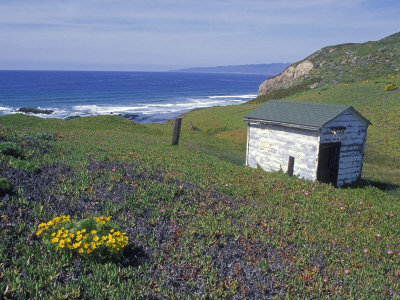
LIGHTHOUSE
AT
POINT CONCEPTION
WESTERN ENTRANCE, SANTA BARBARA CHANNEL
CALIFORNIA.
A Revolving White Light, 1st order of Fresnel,
Shewing a flash every half minute
throughout the entire horizon.
The house is situated near the extremity, and on the highest part of Point Conception, elevated about 220 feet above the sea. It consists of a brick dwelling plastered, of one story and a half, with a low tower also of brick and plastered, rising from the centre. The light is elevated about 250 feet above mean sea level, and will be visible in a favorable state of the atmosphere, from a height of 15 feet above the water, at a distance of 26 statute or 22-1/2 nautical miles.
The latitude and longitude of the Light, as given by the Coast Survey, are:
Lat. 34 degrees 26' 47" N.
Long. 120 degrees 25' 33" W.
The following magnetic bearings and distances in statute miles, are taken approximately from the chart of the coast of the same survey:
West end, San Miguel Island,
S. 12 degrees East 24 miles.
West end, Santa Cruz Island
The light will be exhibited for the first time on the night of the 1st of February, 1856, and thereafter every night from sunset to sunrise, until further notice.
By order of the Light House Board
HARTMAN BACHE,
Major Topographical Engineer, Br. Maj.
Office, 12th Light House District,
San Francisco, CA., December 27, 1855.
|
The Annals of San Francisco
Frank Soule, John H. Gihon, Jim Nisbet. 1855
Written by three journalists who were witnesses to and participants in the extraordinary events they describe. The Annals of San Francisco is both an essential record for historians and a fascinating narrative for general readers. Over 100 historical engravings are included.
Partial Contents: Expeditions of Viscaino; Conduct of the Fathers towards the natives; Pious Fund of California; Colonel John C. Fremont; Insurrection of the Californians; Description of the Golden Gate; The Mission and Presidio of San Francisco; Removal of the Hudson's Bay Company; Resolutions concerning gambling; General Effects of the Gold Discoveries; Third Great Fire; Immigration diminished; The Chinese in California; Clipper Ships; Increase of population; and Commercial depression.

San Francisco, You're History!
A Chronicle of the Politicians, Proselytizers, Paramours, and Performers Who Helped Create California's Wildest City
J. Kingston Pierce
Seattle-based writer Pierce presents a fascinating view of a variety of colorful people and events that molded the unique environment of San Francisco. He chronicles historical highlights: the Gold Rush, earthquakes, and fires and introduces the lives of politicians, millionaires, criminals, and eccentrics.

Click for a Selection of California History Books
including the "Historical Atlas of California," with nearly five hundred historical maps and other illustrations -- from sketches drawn in the field to commercial maps to beautifully rendered works of art. This lavishly illustrated volume tells the story of California's past from a unique visual perspective. It offers an informative look at the transformation of the state prior to European contact through the Gold Rush and up to the present. The maps are accompanied by a concise narrative and by extended captions that elucidate the stories and personalities behind their creation.
Artful Players: Artistic Life in Early San Francisco
Birgitta Hjalmarson
With a handful of wealthy Gold Rush barons as indulgent patrons, an active community of artists appeared in nineteenth-century San Francisco almost overnight. A subculture of artistic brilliance and social experimentation was the result -- in essence, a decades-long revelry that purportedly ended with the 1906 earthquake. Witness Jules Tavernier, hungry and in debt, accepting a stuffed peacock and two old dueling pistols in payment for a Yosemite landscape; Mark Twain as reluctant art critic.

Publications About San Francisco, including Infinite City
What makes a place? Rebecca Solnit's reinvention of the traditional atlas, searches out the answer by examining the many layers of meaning in one place, the San Francisco Bay Area. Aided by artists, writers, cartographers, and twenty-two gorgeous color maps, each of which illuminates the city and its surroundings as experienced by different inhabitants, Solnit offers views that will change the way we think about place. She explores the area thematically -- connecting, for example, Eadweard Muybridge's foundation of motion-picture technology with Alfred Hitchcock's filming of Vertigo. She finds landmarks and treasures -- butterfly habitats, murders, blues clubs, Zen Buddhist centers. She details the cultural geographies of the Mission District, the culture wars of the Fillmore, South of Market . . . This atlas of the imagination invites us to search out the layers of San Francisco that carry meaning for us.