Seaports, Captains, Merchants
° Aberdeen ° Fort Colville ° Hoaquiam ° Port Angeles ° Port Blakely ° Port Townsend ° Puget Sound ° Seattle ° Tacoma ° Vancouver
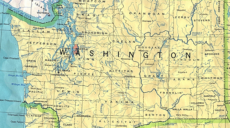
United States: Washington
Aberdeen

Aberdeen is located at the confluence of the Chehalis and Wishkah rivers at the head of Grays Harbor, at the southern end of Washington's Olympic Peninsula. The region's rich fisheries and abundant timber supported a number of Native American communities and served to attract European settlement in the mid-nineteenth century. During the latter half of the nineteenth century a number of small communities were established on Grays Harbor, but Aberdeen quickly grew to dominate as the commercial and cultural hub. Lumber, fisheries, and shipbuilding have fueled the local economy for much of the region's history.
In May 1792 Robert Gray brought the Columbia into the harbor. He named it Bulfinch Harbor in honor of Charles Bulfinch, one of the Columbia's owners in Boston. One of Gray's crew, Fifth Mate John Boit, described "vast many canoes came off, full of Indians." Boit's journal also reveals that although Gray called the bay Bulfinch Harbor, his crew called it Gray's Harbor from the beginning, as did George Vancouver, a British captain who anchored off the entrance to the bay just a few months later, in October.
In 1848, William O'Leary came to Grays Harbor to settle on what would become O'Leary Creek on the south side of the bay. Other scattered settlements grew up around the harbor, but they remained small and did not begin to develop into towns until the 1880s.
Hoaquim
This beautiful 19th century Victorian-style mansion, located in the historic town of Hoquiam, was started in 1897 by lumber baron Robert Lytle and completed in 1900. With his brother, Joseph, they made their fortune with the first electric sawmill on the west coast.

By 1906, their Hoquiam Lumber and Shingle Company was one of the leading cedar shingle manufacturers in the world. After Joseph began building a grand Victorian home on a hill overlooking Hoquiam, Robert determined to outdo him with an even more extravagant 10,000 square foot mansion next door, completed in 1900. Dubbed Hoquiam’s Castle, it was the family home for a decade until they moved to Portland, Oregon. Robert Lytle then gave the home to his niece Theadosia as a wedding present, and she lived there until the late 1950’s.
The home is listed on both state and National Historic Registries, and was recently listed in National Geographic's America's Great Houses.
Lytle acquired his fortune from his electric saw mill which was the first of its kind on the west coast. Theadosia lived in the "Castle" until the late 1950's. .
The house was subsequently left abandoned for several years, the neighborhood children used to slip in and play haunted house and roller skate. In 1968 the house was purchased by the Watson family.
Port Angeles

Since it was officially established as the location of the Custom House in 1861, Port Angeles has had a long and colorful history. Don Francisco de Eliza discovered the deep-water harbor in 1791. All trade in and out of Port Angeles came through the harbor and today the Port of Port Angeles still maintains a vigorous harbor for trade and commerce. Port Angeles was established as a town site by Abraham Lincoln in 1862 by executive order which led the Board of Trade in 1890 to call it the "Second National City", Washington DC being the first.

Most of the land was held as a military reserve until 1894. Forest and fishing industries played major roles in the boom and bust economy of Port Angeles. The regenerative forest around Port Angeles supplied the building materials for Seattle, San Francisco and beyond. Salmon was king of the Strait and plentiful for all to fish.
The Port is on the Olympic Peninsula, where hot springs in Olympic National Park were touted for their medicinal value early in the 1900s. Residents of Seattle made the 3-5 day journey to spend a week at Olympic and Sol Duc Hot Spring Resorts. They arrived in Port Angeles or Port Crescent on the "Mosquito Fleet" (independent ferries that were the major transport in Puget Sound) and then travel by wagon through the forest.
January 20, 1896, San Francisco Call, San Francisco, California, U.S.A.
PUGET SOUND TUGBOAT COMPANY
Offer Made for Its Removal Front Port
Townsend to Port Angeles.
PORT ANGELES, Wash., Jan. 19.— An effort is being made here to secure the removal of the headquarters of the Puget Sound Tugboat Company from Port Townsend to this city. The company has announced its intention of moving from Port Townsend to this city.
The reason for this change is that during the past year their city and county taxes have been raised 90 per cent. President C. E. Mallette of the Chamber of Commerce of this city has wired the tughoat company that no water charges and no taxation for five years are the inducements offered for five years if the company will remove its headquarters to this port. The geographical location of this city and its excellent harbor would make it a most desirable point on the sound for the company to select.
September 24, 1896, San Francisco Call, San Francisco, California
PORT ANGELES DESERTIONS.
Twenty Men Leave the United States Cruiser Philadelphia and Are Not Recaptured.
PORT TOWNSEND, Wash., Sept. 23.
The disbanding of the naval fleet at present concentrated at Port Angeles for maneuvering will occur at an early date. All but two of the vessels will return to Mare Island, the exceptions being the Bennington and the Monadnock, which are scheduled to spend a couple of weeks here before leaving the Sound. The mobilization has been beneficial in thoroughly drilling the men, but disastrous as regards dasertions, twenty men having recently left the Philadelphia in a body. Owing to the ruggedness of the country about Port Angeles, it is extremely difficult to capture deserters.
February 1898
THE WHITELAW PUTS IN AT PORT ANGELES.
Passengers Compel the Captain to
Take Aboard a Supply of Fresh Meat.
PORT ANGELES, Feb. 22.— The steam schooner Whitelaw put in here last night 107 hours from San Francisco, bound for Dyea, with 150 passengers. There was much dissatisfaction on the part of the passengers on acccount of the meat served. It was the original intention of the Whitelaw to take the outside passage, but the passengers compelled the captain to come here for fresh meat and take the insiue passage. The rumors of mutiny of the Whitelaw's crew were unfounded.
June 12, 1899, Los Angeles Herald, Los Angeles, California
A Costly Mistake
Port Townsend, Wash., June 11.—Capt Fretwurst of the British bark Natuna„ which arrived at Port Angeles this morning has made a costly mistake, owing to a similarity of names. The Natuna sailed from Antwerp December 22 with a cargo consigned to W. R. Grace & Co., Port Los Angeles. The captain evidently, after leaving port, on locating his destination on the chart, picked out Port Angeles instead of Port Los Angeles, and sailed for that place, not realizing his mistake until he attempted to enter his vessel at the custom house. He found that he had sailed about 1200 miles north of his destination.;
Port Blakely

Generally when someone mentions a "frontier town," images of mining or cattle towns come to mind. But along America's coastlines, logging was a pioneer industry. Europe had decimated her forests, and America's Eastern Seaboard was being used for lumber from the time the pilgrims first arrived in the 1600s and by the 1700s, ships were being built along the Eastern Seaboard from Maine to Virginia. Those ships carried lumber to Europe, and around the Horn to San Francisco; a treacherous undertaking at best.
At late as the Gold Rush, ships were still bringing lumber around the Horn.

Then, during the 1850s, mills began appearing along the West Coast just north of San Francisco up into Oregon, Washington and British Columbia. By the 1880s, more than 400 mills were operating in California's Humboldt Forest region alone.
The Puget Sound area of Oregon's protected coastline enjoyed an ice-free climate year round. In 1863, William Renton built the Port Blakely Mill on the southeastern shore of Bainbridge Island. A partner, Charles S. Holmes, supervised marketing activities from his San Francisco office. Because of a lack of water, activities were extended through the acquisition of "Puget Sound & Grays Harbor," line which was changed to the G.S. Simpson Co., and the line extended.
By 1883, the Northern Pacific Railroad was completed, providing a overland connection with Eastern markets. By 1885, the Port Blakely Mill was the world's largest, employing 1,200 men cutting 400,000 feet of lumber per day.
The company also purchased the Russian gunboat Politokofsky, stripped it of its guns, and used her as a carrier around Puget Sound. Renton also purchased five lumber schooners as carriers, and a tugboat to shove logs around on the Sound. When the Hall Brother's Shipyard was constructed near the Port Blakely Mill in 1881, the S.S. Julia — the largest stern wheeler in the Northwest — was built, along with scores of schooners and other craft.
July 1890, Sacramento Daily Union, Sacramento, California
On A Reef
The Schooner Guido Disabled Near Tom Point, Washington
July 3d.— A special from Port Townsend says: The schooner Guido, which loaded lumber at Port Blakeley and sailed for San Francisco a few days ago, ran on to a place known as Tom Point, between Dungeness and Port Angeles. The tide was very swift, and the chain began cutting her hull down, but before much damage was done tbe chain parted and the schooner drifted on the reef where she was sighted by the tug Mogul yesterday, which rendered her assistance and towed the vessel off. Considerable damage was done to the vessel. She was towed to Port Blakeley, and tbe deck-load of lumber will have to be discharged in order to repair the vessel.
Port Townsend
Thursday, April 3, 1890, The Morning Oregonian, Portland, Oregon, U.S.A.
Why Port Townsend is Destined to be a
City of Great Importance!
Reason 1: It has the best harbor of Puget Sound, from Cape Flattery to Olympia, having the most convenient anchorage over the greatest area, from 5 to 15 fathoms deep, with the best holding ground. There are no bars, shoals, rocks or hidden dangers of any kind throughout the entire bay, which is land locked and well sheltered from the stormy winds and from the heavy ocean swell.
Reason 2: Ease of approach from tech ocean. A sailing vessel can run direct from tech ocean to the anchorage in Port Townsend Bay, with a westerly wind, or beat up to her anchorage with an easterly wind, the Straits of Fuca being over 12 miles wide, while above Port Townsend to any of the cities the navigation is more intricate, requiring the constant use of tugs. Steamers can run the distance from tech ocean to Port Townsend during the densest fogs by aid of their compass alone, there being no hidden danger to apprehend.
Reason 3: It is the port of entry of Puget Sound, and its geographical position is such that it will afford greater facilities to commerce over a greater extend of country than any other position on Puget Sound.
Reason 4: It is at the entrance to Admiralty Inlet and within the lines of the proposed military works for the defense of Puget Sound, and is where the naval squadron will have a rendezvous, and where the government will build a dry dock for repairs, and a naval station for supplies for our naval vessels and the merchant marine
Reason 5: It will become the great wheat shipping point on the Pacific Coast. it has been ascertained that from the junction of the Snake and Columbia Rivers to Port Townsend, there is a fall of about 400 feet, and that it is practically very nearly a level grade and that one engine can haul 25 loaded cars to Port Townsend, while it takes two engines to haul 14 loaded cars through the tunnel to Tacoma. The peninsula which lies between Port Townsend and Port Discovery harbors, presents on both these harbors a greater extent of waterfront than any other position on Puget Sound, both of which can be utilized by one line of railroad, thus offering greater facilities for handling vast quantities of wheat than can be found elsewhere in the whole country.
Reason 6: It will be the headquarters and great point of transit of all the whaling fleet, which can here ship all their oil and bone to Eastern markets and save 700 miles of ocean travel, which they now have to take to transport these products to San Francisco.
Reason 7: It will be the headquarters of the flabbing business. The Union Pacific Railroad Co. state to the senate committee on relations with Canada who were here in 1889, that they intend putting in refrigerator cars to take fresh fish through on the long haul at greatly reduced rates, and will here ship all the salmon pack, as well as other fish products destined for the interior and Eastern market.
Reason 8: It is the point of departure for all passengers and freight to British Columbia and Alaska, and its unrivaled scenery makes it the admiration of all tourists who have ever visited Puget Sound.
Reason 9: It is the location on the smelting works of Irondale, on Port Townsend Bay, where the best charcoal iron known in the world is produced. A plant will be put up at these works by the company to manufacture steel plated for boilers and for building vessels, steel rails and all iron material required for railroad construction and every kind of iron for blacksmith use.
Reason 10: Port Townsend, by its geographical position, is intimately and directly connected with Portland, being due north, as can be seen on any map. The Willamette meridian, which commences in Portland as its initial point, terminates in Port Townsend bay, between Point Hudson and Marrowstene Point. The Port Townsend Southern railroad will soon connect the two cities, and Port Townsend will become in fact one of Portland's most important shipping points.
Reason 11: Because on the peninsula between Port Townsend and Port Discovery bays will be built within the very near future the most important city on the Pacific Coast, a city that will be fostered and developed by the Union Pacific railroad, which will here have its grand western terminus, from whence will proceed lines of great ocean steamships which will bring in the commerce of Asia and China and the South Seas.
Puget Sound
SS Indianapolis was built by the Craig Shipyards at Toledo, Ohio in 1904. 765 tons, Length: 180' Beam: 32' Draft: 18' 6", Propulsion: triple-expansion steam engine, Horsepower: 1,500 Speed: 16 knots. The Indianapolis spent the last years of her life carrying cars from Edmonds to Port Townsend, Washington. With the arrival of the ferries from San Francisco, the Indianapolis, with her costly steam power plant was soon withdrawn from service.
June 17, 1869, Sacramento Daily Union, Sacramento, California, U.S.A.
Bark "Tidal Wave."

The largest vessel ever constructed on the Pacific coast was recently launched at Port Madison, Puget Sound. She was built entirely of Puget Sound fir, by W. J. Bryant, for Meigs & Gawley. Her mold is nearly the same as that of the bark Northwest, recently built by the same parties, but is about thirty feet longer. She is named the Tidal Wave, is about 600 tons, and is commanded by Captain Reynolds, formerly of the bark Gold Hunter. She will carry about 750,000 feet of lumber. She has wire rigging, is single decked, and is in every respect a first class vessel. She is now loading lumber at the Port Madison mills, for this port.
Puget Sound, Albert Bierstadt.

In 1870, Albert Bierstadt painted one of the most novel subjects of his career: Puget Sound on the Pacific Coast. The canvas resulted from newly reawakened interest in a region the artist had visited only briefly seven years before. Although Bierstadt claimed to have painted "a portrait of the place," he had never actually made it to Puget Sound in 1863 and the painting has long been dismissed as another "superb vision of dreamland." This book reveals the fact-within-the-fiction of Bierstadt's spectacular, eight-foot-wide view of Puget Sound. It follows his travels around the Washington Territory in 1863, travels that were far more extensive than previously known.

Tacoma

Situated above Commencement Bay on bluffs that were home to the Puyallup Tribe and other native peoples for millennia, the county seat of Pierce County possesses a natural harbor that was admired by the sound's earliest Euro-American explorers. In 1873 the Northern Pacific Railroad selected it as its western terminus which helped established the community as a regional center for Pacific Rim shipping, forest products, and arts.
Picturing the Alaska-Yukon-Pacific Exposition: The Photographs of Frank H. Nowell
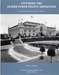 Held during the summer of 1909, was the first world's fair held in Seattle. Capitalizing on the popularity of the booming gold rush, the exposition was designed to showcase the riches of the Pacific Northwest and highlight trade with the Pacific Rim nations and beyond.
Millions of visitors came to Seattle to experience the one-of-a-kind attractions, exhibits, and events held during the AY PE, which became the footprint for the modern University of Washington campus. Many of these visitors stayed to populate the growing metropolis. From the ornate European-style architecture to the fountains and gardens, the amusements of the Pay Streak, and the exotic Oriental exhibits, the AYPE entertained and educated while bringing needed business to Washington State.
Spirit of the First People:
Native American Music Traditions of Washington State
Willie Smyth
Spirit of the First People is a collection of personal narratives, stories, and essays on the music of the First People in the region that now encompasses Washington State. From tribe to tribe and reservation to reservation across the state, a wide range of musical genres and individual styles have developed, including social dance songs, game songs, and hymns.

Company Towns of the Pacific Northwest
Linda Carlson
University of Washington Press
"Company town" evoke images of rough-and-tumble loggers and gritty miners, of dreary shacks in isolated villages, of wages paid in scrip good only at price-gouging company stores, of paternalistic employers. But these stereotypes are out-dated, especially for those company towns that flourished well into the twentieth century. The author provides a more balanced look at these "intentional communities." Many of the later towns attracted professionals as well as laborers; houses were likely to be clapboard Victorians or shingled bungalows; and the mercantile store carried work boots, baby diapers, and Buicks and extended credit even to striking workers. Company owners built schools, power plants, and movie theaters. Drawing from residents' reminiscences, contemporary newspaper accounts, company newsletters and histories, census and school records, and site plans, the book looks at towns in Oregon, Washington, and Idaho, considering who planned the towns and designed the buildings. It examines how companies went about controlling housing, religion, taxes, liquor, prostitution, and union organizers. It tells what happened when people left--when they lost their jobs, when the family breadwinner died or was disabled, when mills closed.
Northwest Coast Native and Native-Style Art: A Guidebook for Western Washington
Lloyd J. Averill, Daphne K. Morris
This resource book by former University of Washington lecturer Averill and Native art educator/illustrator Morris combines effective approaches to touring, viewing, and learning about the Native arts of the Northwest Coast region.


The Mapmaker's Eye
David Thompson on the Columbia Plateau
Jack Nisbet
David Thompson was a fur trader, explorer, and meticulous geographic surveyor. He was, and is, the English and Canadian counterpart of Lewis and Clark. He visited the Mandan villages on the Missouri River in 1798. He crossed the Continental Divide in 1807 and spent five winters on the west side of the divide trading with the Indians. He explored the Columbia River from its origin to the Pacific Ocean. He kept complete journals. He was a better writer than Meriwether Lewis, although not Lewis' equal as a naturalist. He took astronomical readings and did his own computations of both latitude and longitude. Because of this, his maps were much more accurate than those of William Clark. Later in his life, Thompson helped survey the boundary between Canada and the United States.

Site Search

Warships of the World to 1900
Lincoln P. Paine.

True Yankees: The South Seas and the Discovery of American Identity
(Johns Hopkins University Studies in Historical and Political Science)
Dane A. Morrison
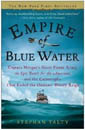
Stephan Talty
Navigation Rules and Regulations Handbook
U.S. Coast Guard
The Navigation Rules & Regulations Handbook supersedes Commandant Instruction M16672.2D This edition includes LNM 39-15 and NTM 41-15 33 CFR 83.01(g) requires: "The operator of each self-propelled vessel 12 meters or more in length shall carry, on board and maintain for ready reference, a copy of these Rules."

American Merchant Ships
1850-1900
Frederick C. Matthews