California
NORTHERN CALIFORNIA: ° Alameda:
° Berkeley ° Oakland
Contra Costa County: ° Crockett, ° Martinez ° Port Costa
Marin County: ° Point Reyes, ° San Rafael (China Camp), ° Sausalito, ° Tiburon
° Mendocino ° Sacramento
San Francisco (City and County)
Solano: ° Benicia (St. Paul's Church), ° Vallejo,° Mare Island
Sonoma: ° Petaluma ° Fort Ross
CENTRAL & SOUTHERN CALIFORNIA: ° Long Beach ° Los Angeles ° Monterey County ° San Diego County ° Santa Barbara ° Santa Monica ° The Channel Islands
San Diego
In 1850, the first steamship line between San Francisco and San Diego was established, touching at San Pedro, Santa Barbara, San Luis Obispo, and Monterey. The first line was owned by a San Franciscan named Wright. In 1856 he transferred it to the California Steam Navigation Company, and they soon sold to the Pacific Coast Steamship Company.
The first steamers were the Ohio, Goliah, and Fremont, while the Southerner, Senator, and Thomas Hunt also ran at times. In later years the Ancon and Orizaba were the regular coastwise steamers. They were all side-wheelers of small tonnage. As they approached the wharf at San Diego, it was the custom to fire a cannon-shot from the bow, to give notice of their arrival.
The Pacific Mail Steamship Company's steamers from Panama also called in San Diego twice a month. Among those calling in 1851 were the Northerner, Tennessee, and Antelope.
Under American rule, the coastal trade up and down the West Coast of the United States opened quickly. In the Herald, May 29, 1851, the marine list for ten days shows eleven vessels of all classes arrived and ten cleared, and the following week four arrived and three cleared.
In December of 1852, traffic was so brisk that the steamer Sea Bird was chartered from the Pacific Mail Company and put on the route between San Diego and San Francisco by Captain Haley. In 1857 two packets ran regularly to the Sandwich Islands. The fare for passengers was $80, and the trip was made in about twelve days.
The first boat of American build regularly used on San Diego Bay is believed to have been the one brought to San Diego in 1850 by Lieutenant Cave J. Couts. It was built for the use of the boundary survey expedition under Lieutenant A. W. Whipple, and first launched in Lake Michigan. This boat was 16 feet long and 5 feet 6 inches wide. It was equipped with wheels on which it traveled overland, and was used for crossing rivers on the way. At Camp Calhoun, on the California side of the Colorado River, late in the year of 1849, Couts purchased this boat and used it for a ferry. On his return to San Diego, he brought it with him and used it to navigate the waters of San Diego Bay.
On August 13, 1857, the schooner Loma, the first vessel ever built on the San Diego Bay, was launched. She was built at the shipyard of Captain James Keating, and was christened, as the Herald informs us, "in due and ancient form."
The Goliah Steamer
"paying out" the electric wire.

Pacific waters along North and South America are littered with ships that wrecked in the dense fogs off of the coastline. The steamship Golden Gate, Captain Isham, wrecked in January, 1854. This steamer came up from Panama with a large number of passengers. She broke a shaft, below San Diego, and came in with only one wheel working, arriving on Wednesday the 18th. Her provisions were nearly exhausted and the passengers very hungry. After securing supplies, she put to sea again on the evening of the same day, in a storm. Her engine gave out, and, in spite of attempts to anchor, she was driven ashore on Zu inga shoal.
The Goliah was in the harbor and went to her assistance, but could do nothing. The next morning the passengers, after a night of terror, were taken off in safety with the exception of one man, I. M. Gibson, who was killed by falling down the steamer's hold in the night. The passengers were distributed among the houses of the town, and considerable difficulty was experienced in providing accommodations for them all. One of their number was the Very Reverend Wm. I. Kip, then on his way to take charge of the new Episcopal bishopric of California. The use of the court-house was secured for him and he preached one sermon while here.
The Southerner arrived the next day, and with the Goliah carried the passengers away soon after. The steamer Columbia arrived on the 20th and, the storm abating, succeeded after hard work in pulling the Golden Gate safely off the sand-bar, just a week from the day of her arrival. She had three feet of water in her hold, but was not badly damaged, and soon left for San Francisco and arrived safely.

The Star of India, still berthed in San Diego, is the world's oldest active ship. She was built of iron at Ramsey Shipyard in the Isle of Man in 1863 at a time when most vessels were still being built of wood. Within five months of laying her keel, the ship was launched into her element. She bore the name Euterpe, after the Greek goddess of music. Euterpe was a full-rigged ship and would remain so until 1901, when the Alaska Packers Association rigged her down to a barque, her present rig.
The Star of India began her sailing life with two near-disastrous voyages to India. On her first trip she suffered a collision and a mutiny. On her second trip, a cyclone caught Euterpe in the Bay of Bengal, and with her topmasts cut away, she barely made port. Shortly afterward, her first captain died on board and was buried at sea.
After such a hard luck beginning things calmed down and Euterpe made four more voyages to India as a cargo ship. In 1871 she was purchased by the Shaw Savill Line of London and embarked on a quarter century of hauling emigrants to New Zealand, sometimes also touching Australia, California and Chile. She made 21 circumnavigations in this service, some of them lasting up to a year. In 1923, the Alaska Packers owned her and changed her name to the Star of India.
By 1923, steam ruled the seas and the Star of India was in San Diego. In 1976, the Star of India was fully restored and under sail.
January 15, 1887, The American Settler, London, United Kingdom
SAN DIEGO

San Diego is a very good harbour, not only fair to look at, being long and lake-like and having a placidity that is in striking contrast to the so-called harbours that lie between San Diego and San Francisco, but perfectly safe; by all means the best harbour on the coast, excepting that of San Francisco. It is formed by two arms of the mainland, one reaching southward and having Point Loma for its extreme end, and the other extending northward from Mexico, and known as the Coronado Beach.
Between the two points of land, that come within a mile of each other, is the channel connecting the harbour with the ocean. So soon as the vessels pass Point Loma they enter the calm waters of this inland passage, and sailing through it, are conducted easily and speedily to the harbour, which has a length of about ten miles, and a width varying from one to three miles. At the present time there is not everywhere a sufficient depth of water to render the harbour all that is claimed by the San Diegans; there are shoals and mud-flats that few steamers can be floated over. But the channel from the Pacific to the wharf is navigable for the largest craft, and a moderate sum expended in dredging will make a landlocked bay, capable of containing at one time more ships than will be likely to visit the city for years to come.
Whenever we came back to San Diego, after a day of wandering about its suburbs, we were greeted by the bay, and forced by its beauty to admire the most southern city in California. Seeing so much water made us forget the dunt of the highways and the dull hues of the sandhills, and gave as much freshness to the picture as though there had been fragrant meadows and a winding river, the old familiar landmarks of a New England scene. And we had become fully acquainted with the actual merits of the harbour, and realized its importance to the city even the San Diegans themselves were not more enthusiastic than were we, newcomers to the place and but visitors at that. From our window, during the deliciously cool evenings of July, we could watch the steamer, with its many lights, move slowly through the channel to and from the wharf; and during the day could see the sailboats flitting about a place which, if San Diego goes on increasing in size and importance, will soon be the anchorage of ships from China and Australia and Mexico that will have selected this port because it is nearer the East than San Francisco. At San Diego the "Southwest Institute" has been established, the aim of the school being to afford opportunities for instruction in all branches of learning for both girls and boys. One of the important features will be the study of music. Girls who come from a distance will be received into the family of the manager, and a comfortable home near the school will be found for the boys. The sewerage is still defective very defective, if one may believe all he is told. If the climate were not perfect, the evils from lack of drainage would be serious.
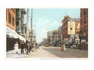 |
Early Downtown Street Scene, San Diego, California |
In going north from San Diego the California Southern road leads through the most interesting and picturesque portion of the San Diego country. Skirting the shores of the harbour, the line passes through Old Town and across the neighboring valley, and then, climbing a low divide, follows the Pacific for nearly forty miles giving a full view of the waves breaking upon the sands. After leaving the beach the road turns inland and enters the San Marguerita valley, a winding opening among low hills that ends at last in the narrow, steep defile known as Temecula Canon. When the first engineers employed on the California Southern came out from Boston and located the new line along the Temecula Creek, they refused to pay any attention to the warnings thrown out by old residents of the region, and laid their rails right in the bed of the stream, which at that season of the year was a mere rivulet falling in an aimless way over its rough, rocky bed. Before the year was over, however, the Temecula had asserted its power, and had become a racing river, deep, strong, wild, tumultuous. It surged down through the canon, carrying rocks and trees along with it, and tearing away with impetuous strength, every vestige of the new railroad. There was not enough left of the California Southern after that rise of the Temecula to pay the stockholders for the paper on which their certificates were printed, and the Greasers and old Californians, who had all along foreseen what would happen, were able to say, " I told you so." When the road was relocated and built the engineers, remembering what had happened once, selected higher ground, and to-day the Temecula stands little chance, no matter how strong an.} swift it may be, of displacing the rails and tits of the line which has been the making of San Diego. On leaving the canon the route toward Colton, where the California Southern meets the Southern Pacific, is over the broad Temecula plains, commanding an extended view of the distant Sierra Madre range of mountains, and from there descends into the great lowland basin in which are the towns of Riverside and San Bernardino, famous at the present time for their groves of oranges and their vineyards. A day train is run over this scenic line of Southern California, leaving San Diego in the morning and reaching Los Angeles early in the afternoon, so that one may see, en route, whatever there is of interest along the line.
Although early August, there was none of the oppressive heat which might be expected in a region so far south as San Diego is, and a clear fresh breeze moved gently inland from the Pacific. There were few tourists, and consequently abundance of room on the cars, and although the grasses along the way were brown instead of green, and the dust was anything but agreeable at times, still one who could not get enjoyment out of the ride deserved never to have the chance of seeing California. A few years ago the beach north of San Diego was inhabited only by a few long-legged storks and sand-birds. Now, since the advent of the railroad, the shore is dotted with new towns, Oceanview, Del Mar, and other places, which consist of long rows of odd little cottages all overlooking the sea. They are cool, comfortable looking towns, suitable for residence, be the season winter or summer, and they have a wide reputation among the people who like to live within sound of the breaking surf. . .
Edward Roberts
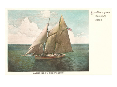 |
Yachting on the Pacific |
Following is a rare early map of San Diego Bay, California, and San Blas, Mexico, published in 1825 by order of Senor Don Guadalupe Victoria, the first president of the Republic of Mexico. Essentially two maps on a single sheet, this map highlights the starting point (San Blas) an ending point (San Diego) of the Spanish supply route to southern California. The upper map focuses on San Diego Bay, covering the region from Puerto Falso (Mission Harbor) to Punta de Arena. The fortress of San Diego (the Presidio), the Ranchera de Choyas, the Poblacion of San Diego (Mission of San Diego), and a ranch and Indian village in the southwestern part of the bay, among other sites, are all noted. The lower map, focusing on San Blas details the Bay from the Rio de Santiago to the village of San Blas, today a small fishing village near Puerto Vallarta. Both maps offer numerous depth soundings, references to shoals, reefs, and other undersea dangers, and notes on anchorage. The armorial crest of Mexico appears in the lower left quadrant. Around the time of the above map, the Spanish government, looking to firm its holdings on the California coast, commissioned a series of nautical charts based on Pantoja s work. The 1810 El Grito, which set off the Mexican Independence movement, halted most Spanish financed map publication work in the Americas. It was left to Mexico s first president Senor Don Guadalupe Victoria to resurrect Spain s abandoned cartographic effort and finally publish this important map series. The Los Angeles Bookseller Jake Zeitlin claimed that this map was published in London by John Arrowsmith. While Arrowsmith s name does not appear on the work, the quality of the paper and the exceptionally fine engraving is definitely suggestive of a well-established European publishing house. No similar work of this quality is evident from either Mexican or American publishers of the period.
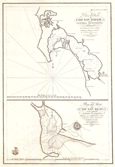
The above is a rare and generally unobtainable map.
It is here for its historical value.
Click on map image to see additional views and information.
1899. World's Fleet. Boston Daily Globe
Lloyds Register of Shipping gives the entire fleet of the world as 28,180 steamers and sailing vessels, with a total tonnage of 27,673,628, of which 39 perent are British.
| Great Britain | 10,990 vessels, total tonnage of 10,792,714 |
| United States | 3,010 vessels, total tonnage of 2,405,887 |
| Norway | 2,528 vessels, tonnage of 1,604,230 |
| Germany | 1,676 vessels, with a tonnage of 2,453,334, in which are included her particularly large ships. |
| Sweden | 1,408 vessels with a tonnage of 643, 527 |
| Italy | 1,150 vessels |
| France | 1,182 vessels |
For Historical Comparison
Top 10 Maritime Nations Ranked by Value (2017)
| Country | # of Vessels | Gross Tonnage (m) |
Total Value (USDbn) |
|
|---|---|---|---|---|
| 1 | Greece | 4,453 | 206.47 | $88.0 |
| 2 | Japan | 4,317 | 150.26 | $79.8 |
| 3 | China | 4,938 | 159.71 | $71.7 |
| 4 | USA | 2,399 | 55.92 | $46.5 |
| 5 | Singapore | 2,662 | 64.03 | $41.7 |
| 6 | Norway | 1,668 | 39.68 | $41.1 |
| 7 | Germany | 2,923 | 81.17 | $30.3 |
| 8 | UK | 883 | 28.78 | $24.3 |
| 9 | Denmark | 1,040 | 36.17 | $23.4 |
| 10 | South Korea | 1,484 | 49.88 | $20.1 |
| Total | 26,767 | 87.21 | $466.9 | |

Site Search

Lighthouses of California
A Guidebook and Keepsake 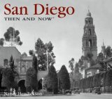
San Diego Then and Now
Nancy Hendrickson

America and the Sea:
A Maritime History
Benjamin W. Labaree, William M. Fowler, Jr., Edward W. Sloan, Jhon B. Hattendorf, Jeffrey J. Safford, Andrew W. German
Spanning the centuries from Native American and Viking maritime activities before Columbus through today's maritime enterprise. A new history of the U.S. from the fundamental perspective of the sea that surrounds it and the rivers and lakes that link its vast interior to the seacoast. America and the Sea has been gracefully written by six prominent maritime-history scholars whose individual areas of research and teaching range from labor to technology, from the fisheries to the U.S. Navy.

Sail's Last Century:
The Merchant Sailing Ship, 1830-1930
(Conway's History of the Ship)
Robert Gardiner
A Historical Survey of the Boiler Makers' and Iron and Steel Ship Builders' Society. August 1834, to August 1904
David Charles Cummings
(OCR Reprint: Typos, etc.)

The Illustrated Encyclopaedia of Ships and Boats
Graham Blackburn.
American Merchant Ships
1850-1900
Frederick C. Matthews

American Merchant Ships and Sailors
Willis J. Abbott

Ship Construction, Sixth Edition
David J. Eyres
Ship Construction is a comprehensive text for students of naval architecture, ship building and construction, and for professional Naval Architects and Marine Engineers as a refresher on the latest developments in ship types, safety and shipyard practices. Beginning with an introduction to ship building and concluding with the finished product, the book enables the reader to follow the construction of a ship from start to finish. Eyres explores in depth, chapter by chapter, the development of ship types, materials and strengths of ships, welding and cutting, shipyard practice, ship structure and outfitting. The new edition includes a new chapter on computer-aided design and manufacture, and all the latest international regulations and technological developments.

The Old Merchant Marine
A Chronicle of
American Ships and Sailors
Ralph Delahaye Paine