Seaports, Captains, Merchants
° Aberdeen ° Fort Colville ° Hoaquiam ° Port Angeles ° Port Blakely ° Port Townsend ° Puget Sound ° Seattle ° Tacoma ° Vancouver
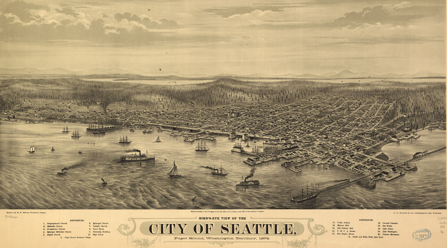
United States: Puget Sound, Washington
Puget Sound extends for 30 miles along the western edge of Seattle. The sound connects with the Strait of Juan de Fuca and ultimately the Pacific Ocean. Water levels here fluctuate with the tides and winds can produce dramatic waves seasonally.
Chinook. Puget Sound. Vancouver. 1883.

For more than 2,000 years B.P., native people lived along the Whulj, the native name for Puget Sound, meaning "the saltwater we know." With the arrival of Europeans in 1774, native populations were devastated by smallpox, measles, and other diseases (as were all indigenous people around the world during early years of seafaring exploration).
Puget Sound covers 1.6 million acres and has 2,500 miles of shoreline. The region’s 2.1 million acres of state-owned submerged saltwater lands are home to 211 fish species, 100 sea bird species and 13 types of marine mammals. There are 68 state parks and 3 national parks, as well as wildlife refuges, national forests and other public lands that border Puget Sound.

George Vancouver was an important explorer of Puget Sound.
He served for 25 years in the British Navy, and commanded the 1791-1792 British expedition to the North Pacific. In April 1792, George Vancouver entered the Strait of Juan de Fuca and commenced his exploration of Puget Sound. He named every island, mountain, waterway, and point of land in sight -- 75 in all, including previously recorded Spanish landmarks.
There are 19 major watersheds in the Puget Sound region. Many major Washington rivers feed into Puget Sound, including
- Nooksack River
- Samish River
- Skagit River
- Stillaguamish River
- Snohomish River
- Cedar River Green/Duwamish River
- Puyallup River
- Nisqually River (1833: The British Hudson's Bay Company set up Fort Nisqually on bluffs above the Nisqually River Delta.)
- Deschutes River
- Skykomish River
- Dosewallips River
- Dungeness River
- Elwha River
Sources: Puget Sound Maritime

George Vancouver's 1792 investigations of Puget Sound and environs were for the purpose of seeking scientific and commercial information. His principal assignment, however, was to arrange meetings with Spanish representatives in Nootka Sound on the west coast of Vancouver Island. Vestiges of the search for the mythical Northwest Passage were also woven into his orders, i.e. to acquire "information with respect to the nature and extent of water communication ... between the North West Coast of America and the country on the opposite side of the continent..."
George Vancouver was the first recorded European to enter Puget Sound above the entrance to Admiralty Inlet. He soon met Captain Robert Gray of the ship Columbia Rediviva, who told him that he (Gray) had discovered the Columbia River. Vancouver did not believe this information, but he changed his mind Broughton, who in the Chatham crossed the Columbia bar a month after Gray had,confirmed that he had heard of Gray's previous visit. The Columbia River issue had far-reaching implications, including the strengthening of America's claim to Oregon.
Puget Sound. 1798. British.

After dropping anchor in 210 feet of water in mid-channel between Blake Island and Bainbridge Island on May 19, 1792, Vancouver began giving names to every prominence and waterway within view:
- Mt. Baker, the 10,778-foot volcanic peak east of Bellingham, was named after his third lieutenant, Joseph Baker;
- Mt. Rainier, at 14,110 feet, honored his friend Rear Admiral Peter Rainier;
- Port Townsend took its name from the Marquis of Townshend;
- Hood's Canal was named for the Right Honorable Lord Hood;
- Marrowstone Point for the island's alleged deposits of marrowstone;
- Whidbey Island honored the master of the Discovery, Joseph Whidbey;
- Vashon Island was named for Vancouver's friend and colleague, Captain James Vashon.
- Restoration Point was first called Village Point for an Indian settlement, then changed to honor the anniversary of the restoration to the English throne of the Stuart monarch, Charles II. Restoration Point, which looks across the Sound at today's King County, served as Vancouver's Puget Sound headquarters.
Sources: HistoryLink.org, Junius Rochester, March, 2003
During the mid-1800s, native oysters were harvested; many were shipped to California. In 1855, on Camano Island, a mill was built to cut ship spars for the FRench and Spanish navies.
Spirit of the First People:
Native American Music Traditions of Washington State
Willie Smyth
Spirit of the First People is a collection of personal narratives, stories, and essays on the music of the First People in the region that now encompasses Washington State. From tribe to tribe and reservation to reservation across the state, a wide range of musical genres and individual styles have developed, including social dance songs, game songs, and hymns.

Company Towns of the Pacific Northwest
Linda Carlson
University of Washington Press
"Company town" evoke images of rough-and-tumble loggers and gritty miners, of dreary shacks in isolated villages, of wages paid in scrip good only at price-gouging company stores, of paternalistic employers. But these stereotypes are out-dated, especially for those company towns that flourished well into the twentieth century. The author provides a more balanced look at these "intentional communities." Many of the later towns attracted professionals as well as laborers; houses were likely to be clapboard Victorians or shingled bungalows; and the mercantile store carried work boots, baby diapers, and Buicks and extended credit even to striking workers. Company owners built schools, power plants, and movie theaters. Drawing from residents' reminiscences, contemporary newspaper accounts, company newsletters and histories, census and school records, and site plans, the book looks at towns in Oregon, Washington, and Idaho, considering who planned the towns and designed the buildings. It examines how companies went about controlling housing, religion, taxes, liquor, prostitution, and union organizers. It tells what happened when people left--when they lost their jobs, when the family breadwinner died or was disabled, when mills closed.
Northwest Coast Native and Native-Style Art:
A Guidebook for Western Washington
Lloyd J. Averill, Daphne K. Morris
This resource book by former University of Washington lecturer Averill and Native art educator/illustrator Morris combines effective approaches to touring, viewing, and learning about the Native arts of the Northwest Coast region.


The Mapmaker's Eye
David Thompson on the Columbia Plateau
Jack Nisbet
David Thompson was a fur trader, explorer, and meticulous geographic surveyor. He was, and is, the English and Canadian counterpart of Lewis and Clark. He visited the Mandan villages on the Missouri River in 1798. He crossed the Continental Divide in 1807 and spent five winters on the west side of the divide trading with the Indians. He explored the Columbia River from its origin to the Pacific Ocean. He kept complete journals. He was a better writer than Meriwether Lewis, although not Lewis' equal as a naturalist. He took astronomical readings and did his own computations of both latitude and longitude. Because of this, his maps were much more accurate than those of William Clark. Later in his life, Thompson helped survey the boundary between Canada and the United States.

Site Search
A Yankee on Puget Sound: Pioneer Dispatches of Edward Jay Allen, 1852-1855


Sailing Directions for the West Coast of North America: The Coasts of Central America, California, Oregon, Fuca, Strait, Puget Sound, Vancouver
Classic Reprint published by Forgotten Books. Author Unknown.
The rapid development of the resources of California and Oregon, and the increase of commerce with countries on the sea-board of Central America, had the effect of raising into importance many ports which initially afforded only an occasional shelter to whalers. As the countries of Western America became more commercially valuable, and the ports visited less as harbours of occasional shelter than as places of trade, a work affording some information to the seaman, however scanty, of the ports was deemed necessary.

Out on the Deep Blue: True Stories of Daring, Persistence, and Survival from the Nation's Most Dangerous Profession
Leslie Leyland Fields, Editor.
the first collection of dramatic, first-person accounts of commercial fishing written by the men and women who work in the nation's most dangerous occupation. Nineteen diverse fisher-writers, from the famous to the unknown, take the reader swordfish harpooning on the Georges Banks, winter crabbing in the Bering Sea, sea-urchin diving off Maine, herring fishing in Alaska, shark-harpooning off Scotland and points between.


A Seaman's Book of Sea Stories
C. S. Forester
American Merchant Ships
1850-1900
Frederick C. Matthews